Hurricane Harbor

A writer and a tropical muse. A funky Lubavitcher who enjoys watching the weather, hurricanes, listening to music while enjoying life with a sense of humor and trying to make sense of it all!

Friday, July 31, 2015

Tropics Friday. Wave Train Leaving Africa. SAL Forecast to Weaken.. maybe..


Back to One . . .

The truth is nothing has really changed.
The models no longer favor the area off the SE Coast.
It didn't catch it's ride yet NE with a trof.
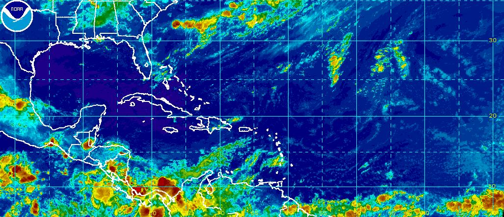
The area of disturbed weather is still there.
It's also still in the GOM.
It's one long trof.

Travel with me to this hard to find link:
http://www.nhc.noaa.gov/text/MIATWDAT.shtml

Long discussion on lingering convection.


This discussion can be found on the NHC page.
But, unlike Playboy everyone goes to the NHC for the pictures...

Peek at the picture first and then read the discussion!!


They update this every 6 hours even when there is no named storm.
It gives you all the news around the tropical basin.
After a while it's easy to understand.

Let's put this in motion:

rb-animated.gif (1120×480)

So... the area from the broad area of convection is still there.
It's in theory leaving Monday NE bound.
In theory..
Cold fronts are unpredictable the first week in August.

The wave off of Africa is hanging in there still.
Running around with SAL...or just below it.
SAL is on top.


Our Invest has a pal and another pal.
All the wave pals are departing from Africa.
SAL is running with them ....
SAL is forecast to weaken a bit.
Each wave pal weakens SAL a bit for the next wave.

We call it a wave train.

The thing about a wave train is that eventually one of them gets through.

Hurricane History is littered with the wave that made it thru...
...in a weak season.

They don't read the weather forecast or El Nino discussion.
They are like Venus in Scorpio...
They hang on... 
They keep dreams alive.
They just keep coming, rolling West

Time will tell........
I'll update as time tells ;)

Besos Bobbi


Thursday, July 30, 2015

Invest 94L should be Dusty for All the Dust It's Running Around with ... Coastal Yellow X Compelling in a Home Grown Year


sat_wv_east_loop-12.gif (640×512)

Not much more to add to the last few posts other than for now the area off the SE coast looks worthy of an Invest. So far, no Invest but that could change fast. I'll put my thoughts out there this morning in that it has a small window of opportunity to develop. It looks more "rooted" than yesterday and yes the "rooted" is my non meteorological term I made up after years of sitting with experts discussing the slow transformation on the Water Vapor Loop from a mess or blob to an Invest to Tropical Named Entity. My blog...my words, my grammar :)

Seriously, it's there. It's stealing the thunder from the messy area of convection on the Gulfside in the NE GOM. As temperatures climb today the convection should explode there again. Should being one of those words best not used in hard data discussion. These are merely thoughts I am sharing with you regarding the possibilities of a yellow 10% circle.


Model discussion is almost not important. 
Invest 94L is so far away it doesn't really matter right now.
The Yellow X off of Savannah is moving parrallel to the coast.


The close location to the coast of many beach cities is compelling.
Normally would warrant more attention.
It should warrant more attention as this is the year of Home Grown.
Sorry Invest 94L  . . . 
Makes you look more like a fish storm for now...

So, keep watching to see if there are changes sooner rather than later.

wv-animated.gif (1120×480)

Note, neither are in the most favorable areas.
Both are dealing with their own devils.
A lot of shear, dry air and DUST.


Those clouds in the top left of the image above...
Are dust moving west bound with the Invest.

If this Invest gets a name they should drop the Danny 
And, name this storm Dusty.

Because it is for sure...riding with Dusty.

Besos Bobbi

Ps Thanks for reading and enjoy the music 


More if you are a Dusty fan...


Wednesday, July 29, 2015

2nd Yellow Invest Off the SE Coast. Close IN Area Could be Home Grown Danny... or Invest 94L Could Be Danny

avn_lalo-animated.gif (720×480)

And then there were 2 yellow boxes . . .


Remember the persistent area of convection over Florida?
The one that persisted for days and looked like a yellow bandaid?

It's back.

The track for both of these is below:

'
Let's look at the newest yellow circle on the block...

rb-animated.gif (720×480)

Not sure it's behaving the way they planned.
For now it's just a yellow box without an Invest #
That could change obviously.

Going to leave this for now and start over in the morning.
But, for those of you on the West Coast just reading about this...

We are now watching two systems.

Getting to be that time of year again ...


Models on the main page. 
Spaghetti Models or otherwise.

Latest data this evening showed some models 
getting Invest 94L up near Cat 1 status.
Note I said "SOME" 

IF it were to develop faster it would hook north as some models show.
IF NOT... it travels West as you know with the upper level flow.

Invest 94L currently has a 30% chance of getting a name.
The new yellow circle has a probable chance of getting an Invest.

Will see how they both look in the morning.
After good morning visible.
After the NHC has weighed in on the possibilities.

For now...we are in subtle ways...heating up in the tropics.

Besos Bobbi

Ps... Read the thoughts from earlier as they are still valid.
I'll update in the morning, obviously.

http://hurricaneharbor.blogspot.com/2015/07/invest-94l-yellow-20-circle-cape-verde.html


INVEST 94L. Yellow 20% Circle. Cape Verde Wave. Here We Go Again...


It's far, far away... Cape Verde Wave


Discussion:


INVEST 94L


Up close and personal:


In motion:

rbtop_lalo-animated.gif (720×480)


Okay, sort of like the last one.
Westbound, marginally conducive.

Translation:
 "models like it enough for a yellow circle"

Should be a little red heart.
For trying so hard to impress.
Gonna be breaking my heart...
It's south of the dust zone.
Nice long arms and a sense of organization.


Sort of sad when you get this excited over a 20% yellow circle :(
Well, to be honest the INVEST was really exciting :(

Doesn't even show up yet on the loop below. 
Keep watching, it will.

sat_wv_east_loop-12.gif (640×512)

Watch the bottom right of the screen near the word UNISYS ;)

Let's put this into proper perspective....


Where will it go.... Oh I can't even go there yet...

(shh quick peek at the track)


Sigh....
Just reminds me of those sad long songs.
Here we go again...


Over and over we fall for these beautiful waves :(
There should definitely be a 
Hurricane Trackers Anonymous Group to go to... 

Cause they always go poof
(trying reverse psychology here...how am I doing?)

Stay tuned... we're on it.
Besos Bobbi


Tuesday, July 28, 2015

Illusions of Hurricanes in the Atlantic ... Upper Level Lows & Florida Blobs

sat_wv_east_loop-12.gif (640×512)

Short post here in the "you can't make this up" category. Last frame as of 7 PM.

Seems like Mother Nature decided to be funny and put a Hurricane Symbol as a gentle reminder?


Weird.

Note the wave coming off of Africa.
Note EPAC will most likely spin something up soon with a name.

The NHC is playing hard ball with the GOM BLOB.
Now part of a trough over Florida.
Could something develop?
Can't rule it out.
But doubtful.
Keep watching cause it's that time of year....


Upper Level Lows imitate Tropical Storms

Atlantic isn't advertising any Going Out of Business Sales just yet..


But for now

As always, time will tell

Besos Bobbi

Ps...It's really hot and humid but there's a nice breeze down here


Monday, July 27, 2015

Tampa Bay Mid Level Convective Blob ... E GOM Swirl. All About the Mid Level


Put the above picture in motion 
and
Black and White

sat_wv_east_loop-12.gif (640×512)

You will see the convection converge just off of Tampa

Whether this can work it's way down to the surface....
....remains to be seen.

Woke up early this morning and looked at the radar.
Smiled. Figured it would be ignored.
The Sunrise could not be ignored.
The canal was calling.


Quiet sunrise.
Knew I'd need the coffee to read the DISCUSSION . . . 


Basically they are saying:

"We see it but not blinking right now!"

"Work yourself down to the surface and then we'll talk!!"


NHC Says NADA !!!

Read between the lines tho... 

Miami Forecast Discussion.
Note the word "significant" there... 
means "some" but not the ones we like...


Tampa Bay says more...


Tampa Bay says "weak surface low"

The truth is somewhere in the satellite imagery...
Read the discussion...
Rain, flooding, weather... Summer in Tampa

http://forecast.weather.gov/product.php?site=NWS&product=AFD&issuedby=TBW

Keep watching that swirl off Tampa.
As waves keep shooting off Africa ...
...like pinballs hoping one will get lucky...

Besos Bobbi

Ps.... With the NHC it's all about the European Models...
They obviously don't listen to Meghan Trainor
"Every inch of you is perfect from the bottom to the top"
Boys like a little more booty to hold at night.... 

;)


Friday, July 24, 2015

Hype Happening on Coastal Low Forming and IF Danny is in the wind... Tropics Take Staycations This Summer SE Coast


Still watching the area off the SE Coastline to see if consistent rainfall will favor pressure drops and if a low pressure center will form. There is some model support, though some are still standoffish. The NHC has yet to blink. It's close in and therefore an excellent candidate for this Staycation year that the Hurricanes are all doing so far.

As the discussion said earlier today, the area is drifting South and will merge with a stalled out cold front. When push comes to shove and steering currents collapse things sometimes start to spin.


Join in the discussion on Facebook.

https://www.facebook.com/TropicalUpdates?fref=ts

Post your thoughts, read other's thoughts.

We are all watching.
Most of tropical tracking is watching, waiting . . . 

Watch this loop and if you see color converge off Carolina.
...or Georgia... or Jacksonville...
And you see a spin, something is happening.

The NWS 7 Day Loop has a Low moving up and down.
Sort of anchors itself on and off shore Florida.

http://www.wpc.ncep.noaa.gov/basicwx/day0-7loop.html

Sunday 


Talk on stationary movement ...

Thursday it's trying still...


Pattern seems kind of stuck.
But, that can change.

There's a wave off of Africa.
SAL waiting for it...

And, convection off of the Carolinas.


Florida is messy.
Tomorrow should be a rainy mix over most of Florida.
But, it's summer down here and we are used to it.

sat_wv_east_loop-12.gif (640×512)

Organized activity... 
That is the real point here.

Lot's of sites are hyping the possibilities.
But, for now all we have is possibilities...
....and rain....

Noticed the winds picking up off and on down here today.

There's a big difference between RAIN
and.......
Tropical Storm Rain.
Named Rain.
Danny Rain.

Keep watching.

Besos Bobbi


Thursday, July 23, 2015

Watching the Tropics From the Tropics... Storms, Sunsets, Key West


Good morning from the tropics! The deep tropics, the real tropics . . .

My younger brother had a big birthday and all he wanted to do was wake up in Key West. So, we drove down the yellow brick road to our ancestral home and did what any good ole Conchs would do on their birthday.... We hung out watching the sun rise the sun set and looked at a lot of old documents in the Florida Room at the Key West Library :)  Okay, there was some drinking involved and a lot of praying for it to rain or something. It was about as hot as I have ever seen it in Key West in July. Normal for August but not July. Soo soooo hot and that's pretty much from a local. Barely a breeze and 92 in the shade and "feels like 102" most every afternoon.

So, I was on a brief hiatus from the tropical discussion while I just soaked in the tropics.

Let's take a quick look at the tropics.

The short of it is this... nothing is happening today.


That's the official NHC statement.


A picture being worth a thousand words.


Area close in at end of old dying front is being watched.
A wave out in the Atlantic is there but so is SAL


SAL shows it's face best at sunset. 
Little pieces break off and make it close in the the Florida Keys


This is moments after sunset. 
The red shows darker as it gets darker.
No, it doesn't always look like this...
...but when SAL shows up for the sunset party it does.

Officially there's nada happening.
NHC says NO.

Others say maybe.


\
 Some models see development off of an old stationary front that is hanging off shore near the Carolinas that could turn into something. That's vague, but it's possible. There are tropical waves in the Caribbean but they are West Bound and SAL is doing it's job in the Atlantic inhibiting development as is El Nino in the Pacific causing higher than normal shear across the Caribbean.


My brother...

Me...


So, we go down and watch the sunset. Catch some great local storms popping along the way and drive back again, up and down the Overseas Highway.


Pics below. Keep watching, something will pop up just like the random storm yesterday and while you got time, mow your lawn and go fishing!

Besos Bobbi


Ps Sorry for any typos, am sooo exhausted ;)