Updated! Category 4 Joaquin Anchored Down By Cuba. Moving SW Slowly. Model Discussion & My Thoughts!
Quick update.
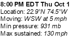
Barometric pressure is dropping.
Expect winds to be higher at 11 PM.


Barometric pressure is dropping.
Expect winds to be higher at 11 PM.
931 MB is LOW.
Joaquin is so close to Cuba it can smell the cafecito...
http://www.ssd.noaa.gov/PS/TROP/floaters/11L/imagery/ft-animated.gif
Seems to be going thru an eye wall replacement cycle.
Pinwheel small eye now.
Dvorak Xray Vision

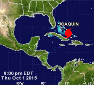
Closer to Cuba than Florida.
Look at small dot of black.
I'll believe the models when they begin to verify.
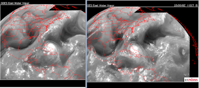
Before and After.
Old on L and Now on R

Still looking trapped.
I'll be back later with more info...
My friend is out of surgery, long day.
Keep praying and thank you for your prayers.
Besos Bobbi
Keep reading.............

Category 4 Hurricane Joaquin
A strong hurricane if you believe the barometric pressure.
The barometric pressure drops before the wind speeds increase.
Stay tuned.
Another image.
Super duper loop!
Just pinwheeling, slight possible lunge West..
Models offer a glimmer of hope for the East Coast.
The NHC responded to the pull to the right by the models.

Note many are going NE
Many are hooking hard NW after N
Many are going North.
If you wonder what the scribble scrabble is in the Atlantic.
It's Invest 90L AKA Ida Remnants

Close up of that Invest.

I have to tell you the truth.
I'm not real impressed with this Invest.
The NHC loves it. The models like it.
If it was the only game in town maybe...
Hard to believe it can exert that much influence on a Cat 4 Cane.
A strengthening Cat 4 Cane.
That's a big concern on that door to Out To Sea
Another look at the models.

11 AM Cone

I outlined the cone as well as the points it should it.
Should being an iffy word.
Still sitting moving SW at 6 MPH
MINIMUM CENTRAL PRESSURE...936 MB...27.64 INCHES
Link to good discussion.
http://www.nhc.noaa.gov/text/refresh/MIATCDAT1+shtml/011504.shtml
$alient point!

That is 140 MPH in 24 Hours.
Some Major Hurricane there... wow.
WOW!
Water Vapor Loop:

Note the pressure from the NE has not really let up.
There's pressure behind the weak front that isn't doing much.
Joaquin seems just anchored there.
My thoughts.
Timing is everything.
Intensity is even a bigger factor sometimes.
So more than everything...
A Major Hurricane can make it's own weather.
It ignore otherwise obvious steering currents.
It can sit and spin and spin and spin.
If it sits too long it misses the trough.
The trough if weak.
Something will grab it.
High builds in behind the trof.
Sometimes this happens and they get trapped.
And, they sit and spin.

You can see this on the beautiful Old School WV Loop.
High digging down, but it's digging at an odd angle.
Joaquin is sort of building a Westward Tail.
It goes down and then just outs to the West.
The real "weather" in the trough is to his North.
He isn't noticing or looking.

Add in some color..
Look at the high pressure building over the top of Joaquin.
High pressure to the left.
High pressure to the North.
High pressure to the NE.
Small window to grab the weak trough.
Well its nice up here but weak down by WPB
IF you were Joaquin ...
...what would you do?
For now he is sitting there, intensifying, taking his time.
Watch out when he makes his move.
My confidence in all the models is LOW at this time.
When he starts to move and we see which is handling him best...
...then I will feel better.
There is a really excellent blog post by Jim Williams.
Explains why the models are always at odds.
Explains why the Euro usually sniffs out the answer.
http://hurricanecity.com/blogs/2015/10/is-hurricane-joaquin-a-threat-to-the-u-s/
Jim is a real expert in tropical meteorology.
He brings his own math and instincts to the table!

At this point if they were dogs...
The GFS would be a poodle.
The CMC a terrier.
The Euro acts like a blood hound...
...or a fox hound.
Keep watching the models as they wiggle about.
Joaquin for now is going SW.
Shame Joaquin can't do Hispaniola ...
... shame we can't have Hispaniola have a go at him.
Right now he seems to be dropping anchor in Cuba

Besos Bobbistorm
@bobbistorm on Twitter
NO that's not me implying things.
That's innuendo... I'll say more later tonight!
posted by BobbiStorm @ 12:17 PM
![]()


0 Comments:
Post a Comment
<< Home