Can Danny Be Rocky Balboa & Beat the Shear? Time Will Tell. Tropical Drama at it's Best. Stay Tuned. Discussion, Maps, Models and Links

Danny at 5 PM is a Cat 3 Major Hurricane.
He made the big time...now a major CNN story
Traveling... WNW at 10 MPH.
115 MPH

There's our little Major Hurricane Danny

Up Close

I'm adding a yellow area over the NRL map.
The current cone of the NHC is shown below
Is on the South side of the model consensus.
Read on and you'll see why I did that.
Either way they have a great map.

A good map to look at...

Shows the Atlantic High Missing in Action!
May I say that the Atlantic High took a fine time to take a hike.
Saturday a low sort of "hangs" over FL

Monday you are looking at a new front as...
...the last didn't do much.

Thursday......note the front didn't make it.
A low shows up that would be what is left of Danny

Here's the loop. Use it tomorrow.
See how much it may have changed or not.
http://www.wpc.ncep.noaa.gov/basicwx/day0-7loop.html
A week from now Danny has weakened.
Gone poof ...according to the above loop.
The front is stuck over Florida.
Tampa is getting more flooding rain.
Any remnants of Danny will be over warmer water.
But where? Really does this loop verify?
I'm a big believer in never trusting beyond the 5th day.
Note the discussion from the NHC by Beven today.
Good discussion.
Important model track info is below.

Note I circled the word "should" in blue.
This is based on a trough "expected to lift Northward"
Ridge builds back in . . .
Danny feels the ridge and turns West.
He admits their cone is on the South side of the models.
As I wrote, before I read the discussion.
Could happen.
Might not.
It's a long ways away still.
Tomorrow is a big day for WATCHING.
How Danny handles the shear.
Where is the shear?
Does Danny continue to move WNW at 10 MPH.
He looks like it's pulling a bit North of WNW.. my thought.
Up Close

Looking at the larger water vapor loop.

You can see Danny plodding WNW at 10 MPH
You can also see Danny gained in size.
Well his pocket gained.
He may be finally meeting his shear...
Note clouds streaming away from him.
There is a system behind him but we can talk about that on Sunday.

This loop shows best the problem Danny is forecast to confront.
He looks like Dan Marino stuck in a pocket with no one to throw to..
The dry air is surrounding him.
And he begins to be cut off from the Monsoon Trough.
Can he scramble long enough to find a receiver?
He has a long tail that is still sucking up warm, tropical energy.
But, he is pulling more to the North away from his comfort zone.

Then again Danny never had much of a comfort zone.
He has always been a fighter.
That worries me.
Fighter sort of cyclones find ways to hang on and survive.
Today he managed to pull off rapid intensification to Cat 3.
No model saw that coming.
Models can't read him well cause he is small.
That concerns me.
There was talk today that he might be weakening
I think it's possible he was trying to go through an EWRC.
Eye Wall Replacement Cycle.
Gutsy move if so...
But that was then and this is now...
Until the High builds back in...
...FL and the East Coast are more open to the approach of a Hurricane.
Note I said "approach" as it can approach and curve out to sea.
If it comes in low and gets into the GOM ..
That could be a problem.
Best case scenario is it does what the NHC forecasts.
High builds in.
He turns West for a while.
That takes him into the Islands.
After he struggles with shear.
Rather than going NW and reaching warm water N of PR.
He could move over mucho land areas.
HAITI and Dominican Republic
CUBA
Somewhere between PR and Haiti he is weakened.
Could he flare back up and reform?
Yes. Small cyclones are more prone to that.
We thought he was dead 2 days ago.
Today he surprised us by being a Cat 3.
If Danny gets past the shear (somehow)
And into the warmer water ...
... he could intensify again rather than fall apart.
That would in agreement with one of the models ..
....that take him North over the Islands.
His best case chance to survive.

Looking at the models on Friday afternoon.
GFS loses it as a weak surface low after the islands around Thursday.
Euro is just weird to me, yet it's a favored model.
Gets weak, falls apart.. possibly comes back in Atlantic N of Islands?
GFDL a model I used to love takes it N of the islands.
GFDL has been stubborn on this.
CMC is made fun of my counted as an important model.
Agrees with GFDL.
Keeps him alive as he does the up and over the island thing.
By the time you read this... they may have changed.
Now look at the model maps.
You can see where the CMC is still moving up through Gulfstream

Note despite the NHC forecast MOST models take the N side of the Cone.
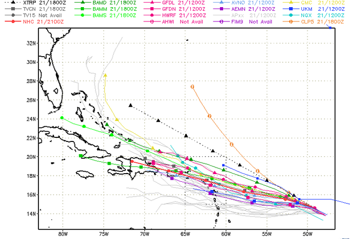
So if the NHC is going with the models ...
...why is the Cone to the South of the models ?

If they make a change it will be at 11PM or 5AM.
They will have a chance to see if today's wild ride is over.
If Danny is following their long range plan.
The NHC has a sort of 5 Year Plan with storms.
Except... it's a 5 Day at a time plan.
The 3 Day is usually on the money.
Beyond the third day with a difficult prima dona storm...
Things can change.
They believe at some point the High will build back in.
Personally I don't like trusting cold fronts in August.
That is my basic problem with the track.
If it' reliant on a trough going through..
High building in over it.
Timing can be off.
Love the image below.
The link is there as well to use to loop.
http://hokukea.soest.hawaii.edu/satellite/satanim.cgi?res=4km&chnl=wv&domain=cta&size=large&period=720&incr=
30&rr=900&satplat=goeseast&overlay=off&animtype=flash
Long link, no time to fix it so ... cut and paste it if you wish.

Danny has to find a way to bust through the dark blue.
That's his mission if he chooses to accept it.
Mind you this can all change tonight when the next model run comes out.
New data from the recon mission will be included and tomorrow...
...might be a whole new day.
Danny may begin to do something other than WNW at 10 MPH.
A bit anal and OCD if you ask me...
I'll be away tonight and back late tomorrow.
I keep the Jewish Sabbath.
So it's my time to breathe a bit.
Rest my fingers and eyes and breathe ;)
And, by tomorrow late in the day I'll have more to write on.
Great sites to check often are:
www.spaghettimodels.com
www.hurricanecity.com
www.flhurricane.com
www.crownweather.com
www.nhc.noaa.org
Message board www.canetalk.com
https://www.facebook.com/TropicalUpdates?fref=ts
Join the conversation...
www.twitter.com
@bobbistorm
Read the post linked below it is filled with Hurricane History.
http://hurricaneharbor.blogspot.com/2015/08/a-dozen-cape-verde-hurricanes-to-think.html
Good to look at models.
But also good to know some hurricane history.
Last but not least here's a link to a great video.
https://www.youtube.com/watch?v=9rSbMcZhMO8
Stay on top of Danny.
He always somehow seems to surprise us.
Just when we doubt him, he fights back.
But.... can he manage to survive the strong shear?
Tropical Drama at it's best.
Sweet Tropical Dreams
BobbiStorm
Does Danny have what it takes to beat the odds?
;)
posted by BobbiStorm @ 3:53 PM
![]()


0 Comments:
Post a Comment
<< Home