Does TD9 Have Tampa In It's Long Term Travel Plans? History might say yes... Models IFFY

Close up on radar as the center of circulation is near land.

This is a tropical depression and needs to be watched. There is a lot of hype out there on a lot of IFS that might happen down the road. Let's stick with reality and what is as well as looking at another system that formed in late October in a relatively slow season and went down in history as one of Tampa's biggest weather events. Hey...it put a kink in the Boom and destroyed all the citrus crops.
Things overhead on TWC.
"Models don't have a good handle on this system"
Funny. I bet the NHC wishes they could say that. No one has a great handle on this system as it is barely there.
This is why I rarely watch the weather or read what people say as I end up getting more annoyed about the way everyone speculates on something barely there and it blows my mind.
There isn't much new to say.
So many questions....
IF it makes it into the Yucatan Channel and Caribbean....what happens?
Answer. The convection will make it across and it's possible the circulation center will or it's also possible a new circulation center will pop up and take over. It's not a Cat 4 Hurricane it's a developing system.
Will it go to Florida?
Answer. Maybe but that's far down the road ...
Will it loop around in the Caribbean?
Answer :

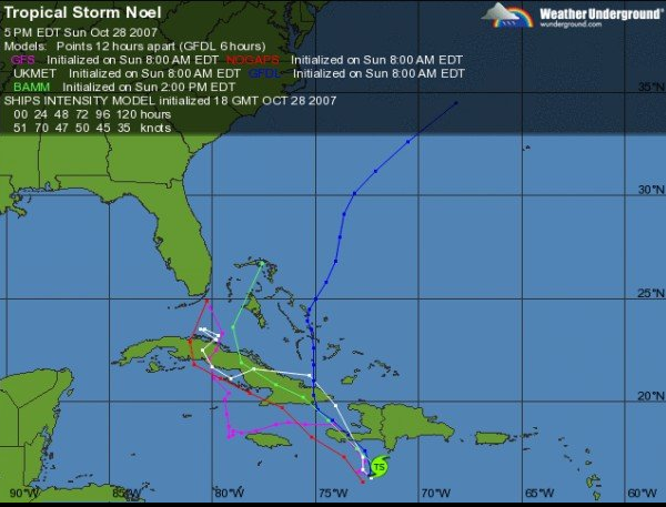
One thing that sometimes says more than models that change on every model run are the Wind Speed Probabilities for selected locations. They do not predict who gets hit the worst, they show trends and patterns. When a city is added further south you know the door is open further south. Belize is in the wind speed probs not Key West. You see.
- - - - WIND SPEED PROBABILITIES FOR SELECTED LOCATIONS - - - -
FROM FROM FROM FROM FROM FROM FROM
TIME 12Z WED 00Z THU 12Z THU 00Z FRI 12Z FRI 12Z SAT 12Z SUN
PERIODS TO TO TO TO TO TO TO
00Z THU 12Z THU 00Z FRI 12Z FRI 12Z SAT 12Z SUN 12Z MON
FORECAST HOUR (12) (24) (36) (48) (72) (96) (120)
- - - - - - - - - - - - - - - - - - - - - - - - - - - - - - - - - -
LOCATION KT
FRONTERA MX 34 7 2( 9) X( 9) X( 9) 1(10) X(10) X(10)
MERIDA MX 34 X 2( 2) X( 2) 1( 3) 1( 4) 1( 5) X( 5)
COZUMEL MX 34 X X( X) 1( 1) 1( 2) 5( 7) 2( 9) 1(10)
BELIZE 34 X 2( 2) 2( 4) 9(13) 4(17) 1(18) X(18)
BELIZE 50 X X( X) X( X) 2( 2) X( 2) 1( 3) X( 3)
PUERTO BARRIOS 34 X 1( 1) X( 1) 2( 3) 2( 5) 1( 6) X( 6)
GUANAJA 34 X X( X) 1( 1) 1( 2) 5( 7) 2( 9) 2(11)
CP SAN ANTONIO 34 X X( X) X( X) X( X) 1( 1) 3( 4) 1( 5)
ISLE OF PINES 34 X X( X) X( X) X( X) X( X) 2( 2) 2( 4)
GRAND CAYMAN 34 X X( X) X( X) X( X) 1( 1) 1( 2) 2( 4)
$$
FORECASTER AVILA
As for models...........
Mike's Facebook Page has lot of discussion. Right now it's all discussion and speculation but worth paying attention to as October storms tend to have surprises.

(like his page on Facebook & join in the discussion)
And the reason is because the GFS refuses to give up the ghost of a FL Landfall...down the road.
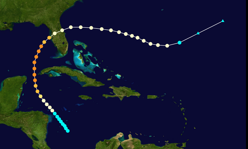
Here's a little bit of history ... I was looking through old pics this morning on my Facebook and found this picture from Noel a storm I mentioned yesterday. I remember when these models came out they reminded me of tulips falling over against the edge of a tall vase. Note I took great pics of Noel as it cruised past Miami Beach.
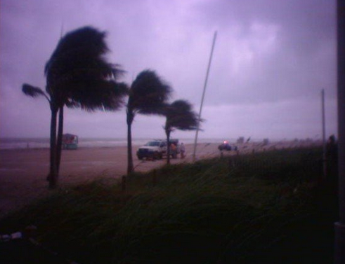
They came and tried to close down the beach. Good luck on that, but the patrol car did clear it "just in case" and then the sky turned this South Beach Deco color.. no filter, crummy camera.. just the way it looked.
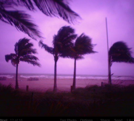
And, that's what South Beach looks like with an offshore hurricane blowing the palm trees & roughing up the surf.
So where will TD#9 go?
Note from the part of the discussion that I am highlighting...the fate of TD9 possibly Tropical Storm Hanna is tied to the fate and movement of the trof.
"If thedepression emerges over the northwestern Caribbean Sea in about 3
days, there is an opportunity for some strengthening. Most of the
global models, primarily the GFS and the HWRF, forecast a favorable
upper-level environment for the system to redevelop, if the
the cyclone survives its path over land.  On this basis, the NHC
forecast now maintains tropical depression status through five days.

Steering currents are weak, and the depression has been meandering
during the past few hours. The cyclone is located at the base of a
mid-level trough, and most likely the depression will drift eastward
for the next 3 days while on the south side of the trough."
So where do we go from here?
Well if you live in Tampa you are REALLY paying close attention.
The infamous 1921 hurricane that hit Tampa was in late October.
http://www.aoml.noaa.gov/general/lib/lib1/nhclib/mwreviews/1921.pdf
Yup... came up out of the Caribbean at the end of a relatively weak season. Jim William's at www.hurricanecity.com has said many times that they are more prone to being hit in a weak season. My words not his quote... his thoughts based on his in depth analysis of hurricane tracks and hurricane history.
Weak season. Well, weak season unless you lived in Tampa.

My family lived in Tampa then.... they saw the destruction up close and personal.

I am NOT saying this IS Tampa's storm. I am saying that it has happened, it could happen but first Tropical Depression #9 has to survive it's travel across the Yucatan and into the Caribbean...
This is a part 1..part 2 scenario.
A lot of IFS...
Some good pics to look through from a great site about Tampa hurricane history. I look through these pics and wonder if my Great Grandfather is one of the men standing by the bay staring at the damage. He so loved Tampa Bay.
http://www.tampapix.com/hurricane.htm
Newest models on Tropical Depression #9

This is labeled "IF" in my pics.
It's a real IF but an IF that many in Tampa do not want to see happen.
Big news day...

Heavy global news story with the shooting in Ottawa.
Multiple shootings of a terrorist kind.
Nobel Prize winner was to meet with the Canadian Prime Minister.
So much developing as news breaks out.. makes TD9 seem insignificant.
Note ceremony in Toronto would have massive security... Ottawa would be a "soft target"
But if it goes on to become Hanna and do Tampa ..it would be historic.
Time will tell..
Besos Bobbi
Ps..........yes I will be updating today as events unravel in the tropics...or are upgraded ... IF and IFFER it seems.
<iframe width="560" height="315" src="//www.youtube.com/embed/gFrXbqsohu8" frameborder="0" allowfullscreen></iframe>
posted by BobbiStorm @ 8:56 AM
![]()


0 Comments:
Post a Comment
<< Home