Tropics...Getting Closer. 20% Yellow Area of Interest

Satellite imagery of the area the NHC highlighted at 2 AM.

Watching tropical development this time of year in a year such as this one that has been plagued by strong Cape Verde Waves with even strong Saharan Dust Storms is a tediously slow process. The newest wave to depart the African coast has a very nice signature. There is a flare up of convection over what should be the center of the wave.
A look tonight shows the lead wave has had a burst of convection as the new wave gets ready to depart the coast. Over Africa is a 3rd wave........ slowly the atmosphere is getting additional moisture from each new wave that takes a bite out of the Saharan Dust Zone.

Further away you can see that suddenly a wave closer to the Caribbean Islands is also flaring up tonight. Note the two pictures are 12 hours apart. Not much there, then suddenly it flares up. I'll show you why in the next picture. I've circled the wave in red. I show this more because it's interesting to see "where" the wave pops as that is where there is the least dust and it is therefore a friendlier environment.

Note that I have drawn a heart with a plus sign in it ...as the only area that is not hostile to tropical development of a wave. I'm not saying it will develop, as much as it will not be sucked dry as it would be further east. Time will tell. But, note it is about where the wave popped with convection over the last few hours.
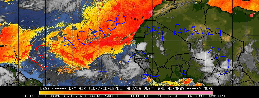
The dust in the Atlantic has a silly "ACHOO" as I'm allergic to dust... Africa is dry despite great waves managing to come up and slam into the wall of Saharan Dust.

There is an ULL to the NW of the lead wave near the Leeward Islands, however it is far enough away not to hurt it... but to ventilate it a bit as well as warmer water and less dust. Let's see how long this wave continues to flare up.
Notice the warmer water...

Lastly, note that there are several areas besides our newest yellow area on the map that could show tropical development. That's a large area of the Tropical Atlantic that has been highlighted in purple, blue and even that odd lime yellow colored where our newest

20 % Chances of development down the road.............
Tropical Weather Outlook Text
TROPICAL WEATHER OUTLOOK
NWS NATIONAL HURRICANE CENTER MIAMI FL
200 AM EDT FRI AUG 15 2014

For the North Atlantic...Caribbean Sea and the Gulf of Mexico:

1. An area of low pressure could form over the eastern tropical
Atlantic by early next week.  Some development of the system could
then occur as it moves slowly westward or west-northwestward.
* Formation chance through 48 hours...low...near 0 percent.
* Formation chance through 5 day...low...20 percent.

Forecaster Beven
Sweet Tropical Dreams...
Bobbi Storm
Ps... Let's see what the models show tomorrow. The area closer to the islands is just interesting to me right now. This year favors close in development, because of the negative conditions further out. However, tonight the area near Africa is lighting up with convection. The problem is always the area in between where Saharan Dust has been in charge. With time..that changes towards the end of August.
posted by BobbiStorm @ 11:02 PM
![]()


0 Comments:
Post a Comment
<< Home