Last Hawaii Hurricane Iniki 1992. Andrew 1992 in Atlantic. Does Linkage Exist?
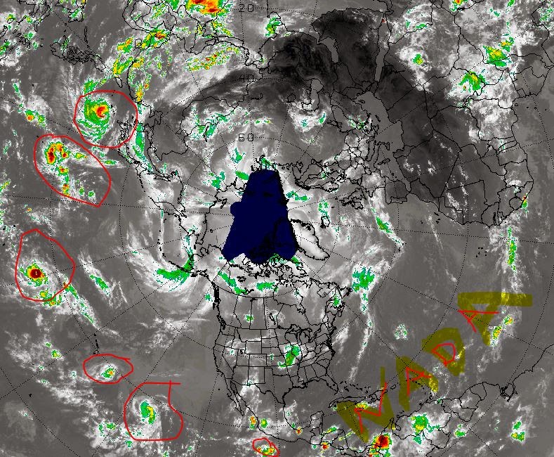
There is way too much going on tropically in the Pacific
...and way too little going on in the Atlantic.
This is good you think............
...........true if you booked an August Caribbean Cruise...
...but Mother Nature has a way of correcting herself.
Linkage is a term we use in International Relations that can be applied to the tropics in ways.
"The intertwining of issues in disputes is known in the literature on international relations as issue linkage."
(It's a lot like the theory of butterfly wings...)
Let's go back to 1992 the last time there was a hurricane that got away from Mexico and made it all the way to Hawaii. We had a huge, dry high in the Atlantic Ocean and an inability to get anything going far out there. That was due to a fading El Nino and we are not in an El Nino currently. But, still we have a huge, dry high over the Atlantic. There were also cold fronts in August over the Carolinas & a high that when it pushed back in it shoved Andrew straight into Miami and... Andrew kept on going all the way to Louisiana.
In the Pacific in 1992:

Pacific in 2014 this year:

Atlantic in 1992... slow sesason with storms forming close in..
..except for Andrew who really didn't develop until close in..
(ignore the blue & see where the color starts.. my point)

Iniki & Andrew 1992

The bigger difference here is that Iniki hit in September and Andrew a few weeks earlier in August. Perhaps this year we will get a big storm in September which is the time most Miamians remember to check the tropics.
As for El Nino it seems the models that have not been spot on the last two years were wrong with the El Nino to end all El Ninos since 1997... (that was also a bad forecast, originally forecast to be a busy season)

So cute all the meteorologists are still waiting for El Nino to form.. well most. I know a few who haven't been holding their breath. Sometimes long range modeling ....doesn't work and we still have a lot to learn.
Actually sort of odd to see the Pacific that busy with out an El Nino the size of Texas...
So it's not my job to razzle and dazzle you with pictures and stories on Hawaiian Hurricanes (cyclones, typhoons, etc) unless it could possibly connect in some way and have some linkage to the Atlantic. I think it does.
Here's one wide shot of the world ....
When the little orange dots begin to grow in the Atlantic... and if anything gets into the Caribbean fronts dipping down would bring it north towards Landfall. The Caribbean and the GOM is hot temperature wise and IF anything were to form close in the to the East Coast (anywhere from South Florida to the Carolinas) it could get messy fast. That's based on history and patterns...not wishcasting.
1992 was a very slow year in the tropics in the Atlantic. Andrew was one of the most devastating, memorable storms in the history of the Atlantic Tropical Basin. It's way too often about quality not quantity.
Something to think on while sipping tea with your lemon meringue pie...
Besos Bobbi
Ps...sometimes things change. Look at that odd hurricane like donut in the middle of the Bermuda High. That's a long story but it is fun watching and I've seen them before. Things change.

Always fun to watch that polar view..
sure sounds Country to me...
https://www.youtube.com/watch?v=f7naHS0oYXg
posted by BobbiStorm @ 8:31 AM
![]()


0 Comments:
Post a Comment
<< Home