Invest 96L Goin Crazy in Hurricane Land... Could Nola Get a Hurricane on Anniversary of Katrina? Or Maybe Miami.. Or Both?
The NHC has been busy today... we now have Invest 96L & both waves have been upgraded with better chances of development. The names Cristobal & Dolly could be blowing in the tropical wind. Or at least Cristobal.

There they both go tracing the Bermuda High. Another more important factor here is that the longer these waves stay weak and take their time forming the more of a chance they have to form closer in with a higher possibility of landfall.
The models are up and ready for viewing on www.spaghettimodels.com

Gotta tell ya... news of the Invest spread fast on Twitter.


It started this morning when everyone was all over the models...... because they showed a hurricane closing in on South Florida...
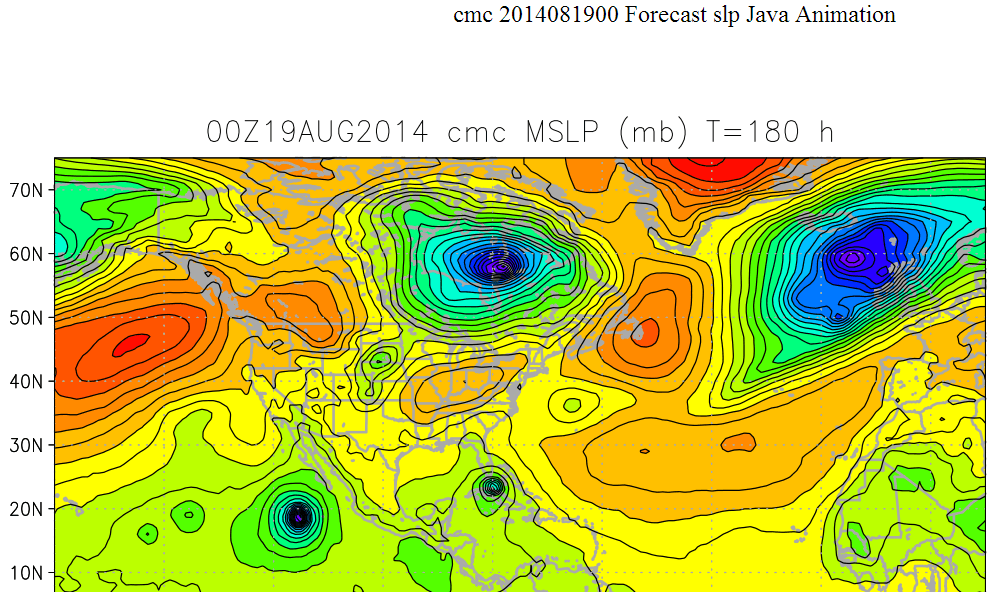
Canadian Model with Miami and the Florida Keys in the cross hairs in 180 hrs
(that's a week's time give or take)
Really the model should look like this...with the big bad Bermuda High sticking its tongue out!

Sort of blood shot eyes if you ask me.......Bermuda High has to be getting tired
I have to admit I have a love hate relationship with the Canadian model. It usually blows up storms and spits out hurricanes that no other model. It's sort of like that old boyfriend that you broke up with and you can't help but drive by their house to see if they are in town or still away at college. You feel really cheap, stupid and silly driving by ... but you do anyway... Everyone loves to make fun of the Canadian... but they do watch it even if no one likes to say they do.
"Look at the Canadian model it does a wham bam thank you mam in a week over south Dade and the Keys...LOL
The next model runs showed Cristobal making landfall near where Katrina did on the anniversary of Katrina. Now we got a new kind of crazy...

NOTE LONG RANGE MODELS ARE NOT TO BE TAKEN SERIOUSLY...
Remember please he lives in Miami..
Please remember he loves tropical weather ...
Understand it's been a dry spell for us and he wants to go to the ocean and ...
I know how he feels. He's going crazy in Hurricane Land.
A lot of us are going crazy.
Every one's been waiting to see what will be with this wave...or that one...or the next one..
Waiting for the wave train to spit out a winner after wave after wave of wannabe hurricanes.
Now we have the models spitting out data and an Invest up on the Navy site.

So this is where we are today . . . a week away from when several models (even respectable ones) believe a named storm will run it's way around the rim of the Bermuda High up towards the SE coast and/or Cuba or shoot the Florida Straits and head into the Gulf of Mexico where the water is really, really, REALLY HOT and become a Hurricane that hits Nola on the anniversary of Katrina.
Could happen but if it does happen it will be named Cristobal... not Katrina and not Camille but Cristobal. Remember that if the models continue to spit out a Nola landfall.
The truth is the way a Cape Verde Wave usually gets into the GOM is a long trek around a strong high moving stubbornly around the periphery of the high... San Juan... maybe Cuba... maybe Miami or the Florida Keys and keeps going all the way through the GOM until the influence of the high lessens and a trough pulls it north... like a tropical choo choo train or conch train ...zoom, zoom, zoom.
The High is in place...so large that at times I think it wants to annex FL, GA & South Carolina..

But usually the Bermuda High breathes... pulsates... sucks in... pushes out... sucks in... so sometimes a hurricane gains latitude before moving WNW again when the High moves back in it's normal place. Note the tracks of Betsy and Andrew where I have taken a red line and straightened out the track showing the average place of the high.. except on those days when it sucked in and moved East enough for the hurricane to gain some latitude.
Betsy was funky wasn't she?

What you see is the general placement of the High when Andrew was rolling WNW..
on any given day it varies and then pushes back in..
(won't show Hugo chart or Fran so as not to freak Carolina friends...)
Sometimes you get a storm like Camille that was a wave that couldn't but then did...


Have to admit it looks pretty good on the floater. Why we want a floater is obvious it sits just above the Invest..floating over it..with it and sending us images at a rapid rate faster than other satetllite imagery. Just so you understand what all the fuss about a "floater" is . . .

http://www.ssd.noaa.gov/PS/TROP/floaters/96L/imagery/vis_lalo-animated.gif
Yup...something is going on. What it is I'm not exactly sure to quote a song...
https://www.youtube.com/watch?v=UEI1cBLe3jc
Battle lines being drawn... between the defenders of the GFS and the lovers of the EURO models.

Seems like if the EURO doesn't like it... it's a No Go to Nola..
..or it could jump on the Cristobal bandwagon tonight or tomorrow
(keep watching)
As for me I'm watching the Bermuda High and the pattern of where the moisture is going and correlating that with where other storms have gone in years like this....and I'm watching the Invest and not counting my Hurricane Warnings until we see if this wave can really wind up into a named entity.
To get a feel for this oozy Bermuda High...loop this loop. Note they have not yet put any system there and note the NHC has yet to put up a floater satellite link though it's coming trust me.
http://www.hpc.ncep.noaa.gov/basicwx/day0-7loop.html
What do I think? I don't as yet see any signs of a real circulation with the orange wave nor the yellow one. But, I do see the pattern. Watch the flow of the moisture and it goes where the models take Cristobal down the road...

The lead wave is trying mind you, but as soon as it starts to spin it falls apart again and then starts to spin again. Persistence is important when calling for development of an iffy system. The models are seeing a hurricane down the road.
There is an ULL to the NW of the lead wave that could help to ventilate it ...or keep it in check. This needs to play out in real time. Yes, the models are great but they often change... Miami is about to be hit by a hurricane... no wait... Cuba...no wait it's in the GOM and it's slamming into Nola...oh hold on... maybe Mobile..

You can see this ULL better on the following long link.
http://hokukea.soest.hawaii.edu/satellite/satanim.cgi?res=4km&chnl=wv&domain=cta&size=large&period=720&incr=30&rr=
900&satplat=goeseast&overlay=off&animtype=flash

(doesn't look too organized does it?)

So now you know WHY everyone has suddenly gone tropically crazy.. So crazy I wonder why we use names like Cristobal vs Candy?? I think a Hurricane Candy would be fun to track...
https://www.youtube.com/watch?v=spc5VKGS-Ks
Trying to stay light and informative today with a little musical help as I watch the models.
Ring around the roses ... which ever model gets the closest...........
Going a little bit crazy in hurricane land... or is it Candy Land?? Maybe it's peppers from Pat Land :) It's good to smile, breathe and be busy...
Stay tuned. I'll update as more information becomes available.
Besos...
Are the models right or.... are they seeing the tropics with beer goggles on?? Is the Euro right once again or is it just slow to jump on the bandwagon?
https://www.youtube.com/watch?v=ORqzaOFUCsg
posted by BobbiStorm @ 12:31 PM
![]()


0 Comments:
Post a Comment
<< Home