Saharan Dust, Deadly Twisters in NY & Lessons Learned From Hurricane Arthur. El Nino Where Are You?
Not a westbound tropical wave is really trying to hold it together despite dry air from Saharan Dust.
A short lesson in how to read the Tropical Weather Discussion is below. I am gong to highlight in bold the important words and add comments in here and there. Note in "slow times" when the NHC does not have a yellow circle or X or whatever they are going with this week on their charts we read the Tropical Weather Discussion. To be honest we look at tons of models, discuss the models with our friends or co-workers and complain there is nothing to track .............and then we reread the discussion while running loops.
Note how many times they say "Saharan Dust" as if they are trying not to scream "SHARK IN THE WATER" but are alluding to it.
Example: Few people were in the water today on Wells Beach Maine as the few people who did venture into the surf came running out alluding to seeing a large object swimming in the water and seemed uneasy about going back until the large swimming object that looked like it had a fin above the water was gone a long time. They have been several reports of people afraid to swim in the water the last few says as they have seen what looks like a fin circling around out there a bit too close to shore.
No, there aren't sharks today there that I know of, but it's my best friend Sharon's favorite beach from her childhood so went with it.
Wells Beach. It's clearly understandable why she thinks Miami Beach is ugly with all those palm trees... rolling my eyes and glad Sharon does not read my blog ;)
http://wellsbeachmaine.com/webcam.html
Atlantic Tropical Weather Discussion
http://www.nhc.noaa.gov/text/refresh/MIATWDAT+shtml/101051_MIATWDAT.shtml?
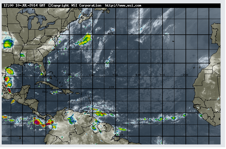
...TROPICAL WAVES...
TROPICAL WAVE CAME OFF THE WESTERN COAST OF AFRICA LATE WED
NIGHT. THIS IS A LARGE AMPLITUDE WAVE WITH AXIS EXTENDING FROM
24N22W TO 10N25W MOVING W AT 15 KT. NO CONVECTION IS ASSOCIATED
WITH IT SINCE THE WAVE IS COMPLETELY EMBEDDED IN THE DRY SAHARAN
AIR LAYER.

TROPICAL WAVE IS WITHIN 320 NM SE OF THE WINDWARD ISLANDS WITH
AXIS EXTENDING NEAR 14N54W TO 5N57W MOVING W AT 20 KT. THE
NORTHERN WAVE ENVIRONMENT IS BEING ENGULFED BY THE SAHARAN AIR
LAYER. SCATTERED MODERATE CONVECTION AND TSTMS ARE S OF 12N
BETWEEN 50W-61W.

A TROPICAL WAVE IS LOCATED OVER THE E CARIBBEAN WITH AXIS
EXTENDING FROM 20N60W TO 12N68W MOVING W AT 20-25 KT. DRY AIR
FROM A SAHARAN AIRMASS IS MOVING ACROSS THE WAVE ENVIRONMENT
WHICH ALONG STRONG DEEP LAYER ENVIRONMENTAL SHEAR IN THE
CARIBBEAN HINDER CONVECTION AT THE TIME.

...DISCUSSION...

CARIBBEAN SEA...
THE AZORES HIGH CONTINUES TO EXTEND A RIDGE AXIS SW INTO THE
NORTHERN CARIBBEAN WATERS. THIS CONTINUES TO SUPPORT A TIGHT
PRESSURE GRADIENT IN THE CENTRAL AND EASTERN BASIN...THUS
SUPPORTING A MODERATE TO STRONG BREEZE 64W-83W WITH NEAR GALE
FORCE WINDS ALONG THE COAST OF COLOMBIA. EXCEPT FOR THE NW
CARIBBEAN AND PORTIONS OF THE NORTH CENTRAL-EASTERN BASIN...THE
REMAINDER BASIN CONTINUES UNDER THE INFLUENCE OF A DRY SAHARAN
AIRMASS WHICH ALONG STRONG DEEP LAYER ENVIRONMENTAL SHEAR HINDER
CONVECTION AT THE TIME.
Going to skip here down to the rest of the Atlantic Ocean discussion... note the Azores High discussion.
ATLANTIC OCEAN...
A BROAD MID-LEVEL TROUGH IS OVER THE EASTERN CONUS EXTENDING AN
AXIS SE INTO ADJACENT SW N ATLC WATERS WHERE ALONG DEEP LAYER
MODERATE MOISTURE SUPPORT ISOLATED SHOWERS AND TSTMS N OF 27N W
OF 77W. OTHERWISE...BESIDES THE TROPICAL WAVES ALREADY
DISCUSSED...THE AZORES HIGH AND ASSOCIATED RIDGE CONTINUE TO
DOMINATE THE ATLC WATERS. HIGH PRESSURE ALONG DRY AIR ACROSS
MUCH OF THE BASIN SUPPORT FAIR WEATHER. BESIDES A SURFACE TROUGH
FOR THE SW N ATLC...NO SIGNIFICANT CHANGES ARE EXPECTED DURING
THE NEXT COUPLE OF DAYS.

FOR ADDITIONAL INFORMATION PLEASE
VISIT WWW.HURRICANES.GOV/MARINE
Now... let's move on to what do I see.
#1 The low down on the Saharan Dust is this... it hinders development almost always. On occasion a wave comes along that finds a way to keep going despite the dust... even if it has to drag the dust all the way to Jamaica and oddly the dust can once in a while spark up development. This is complicated and there are papers written on the subject, but most meteorologists will tell you it inhibits development. It is true that it inhibits development, however it does not exclude development.
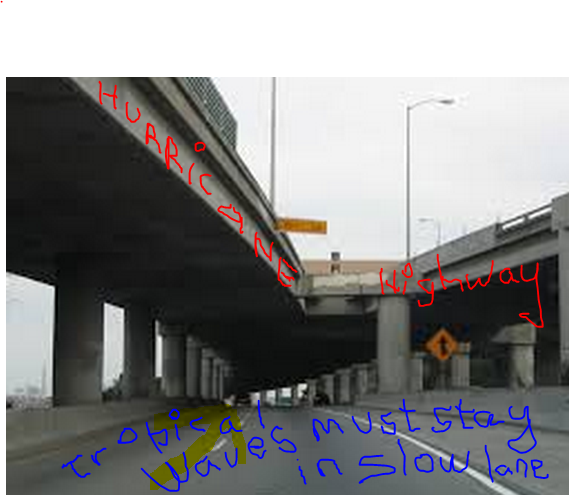
(I am not an artist.... but you get the idea)
#2 Where Saharan Dust goes Trouble follows and that's TROUBLE with a capital T. Why? The dust basically follows the path of air flow throughout the tropics. It hitchhikes much like Tropical Waves do looking for a free ride on the slow, low lanes of the double decker atmospheric highway.

http://tropic.ssec.wisc.edu/real-time/mimic-tpw/natl/anim/latest72hrs.gif
Note a wave tries to get its roll on around 50 W but the DRY SAHARAN DUST has it's way with what would like to have been Bertha.
The dust can be seen vacuuming up the orange & mustard colors around 30W stretching out the whole line too thin... sucking up the moisture. Note the high pushing anything caught under it West... WNW... Hmnn.
Note.. closer to home in the Bahamas if a wave were to get it's groove on it would twist and turn close in and depending on where the fronts are and where they are dipping the East Coast is in play for more land falling storms. They only have two choices there being "out to sea" or "landfall" . . . (shark music)
https://www.youtube.com/watch?v=BX3bN5YeiQs
So... know there is a huge high pushing things west. Because the Saharan Dust AKA SAL allows the weak dry waves to get further west than normal.........if they develop they are closer to prime real estate.
BobbiStorm's Bottom Line:
Saharan Dust does inhibit development far out in the Atlantic, however it also inhibits the development of Fish Storms that curve safely out to sea. What doesn't kill it only makes it stronger is in play and it is stronger close in to the coast. Think Arthur along with hundreds of other hurricanes over the history of the Earth.
Next, despite the lack of tropical weather, Mother Nature found a way to wreak havoc across the US yesterday. A mother and her 4 month old baby were swept off the face of the Earth by a fast forming F2 Tornado in upstate New York. Her aunt also died in a near by home. A family and a small town mourns the loss of these beautiful human souls. Note this happened in New York. Yes, twisters do happen in New York. A very tragic tornado story that you can read about online.
http://www.localsyr.com/story/d/story/sheriff-mother-infant-among-4-killed-in-smithfield/13687/9rN5Qu1ESEGGiVdbDJJ1Gg
According to the Sheriff’s Office the following people were killed:
- Kimberly Hilliard, 35
- Paris Newman, 4 months old
- Virginia Warner, 70
- Arnie Allen, 53
My reason for mentioning it other than honoring the passing of their lives is to point out that New York has been in play all year for weather and that will continue into the hurricane season.
Record winter storms.
Spring storms.
Summer storms.
Connect the dots. The atmospheric lines connect.
As wonderful as it would be to get rid of the horrifying heat that has gripped parts of the nation including New York, NJ, Maryland... it's also not a great thing to have fronts dipping down during hurricane season when hurricanes form close in.

The reason Hurricane Arthur decided to visit the Pamlico Sound is because a retrograding low pressure system um... retrograded (went west) and it pulled the storm with it just enough for it to miss OBX. There is a longer explanation, but keeping it simple. Look at the above picture. Imagine a weak wave got into the Gulf of Mexico, intensified over the very hot Loop Current on the one day this summer when shear was weak.. and moved North or NNE up to meet that type of Polar Guy?? A recipe for trouble.
Lastly... a few lessons learned from Hurricane Arthur.

A difference of 30 or 50 miles can make a big difference.
Don't think because you are ont in the middle of the cone you will not see the hurricane....
"a hurricane is not a dot" says Mark Sudduth so correctly
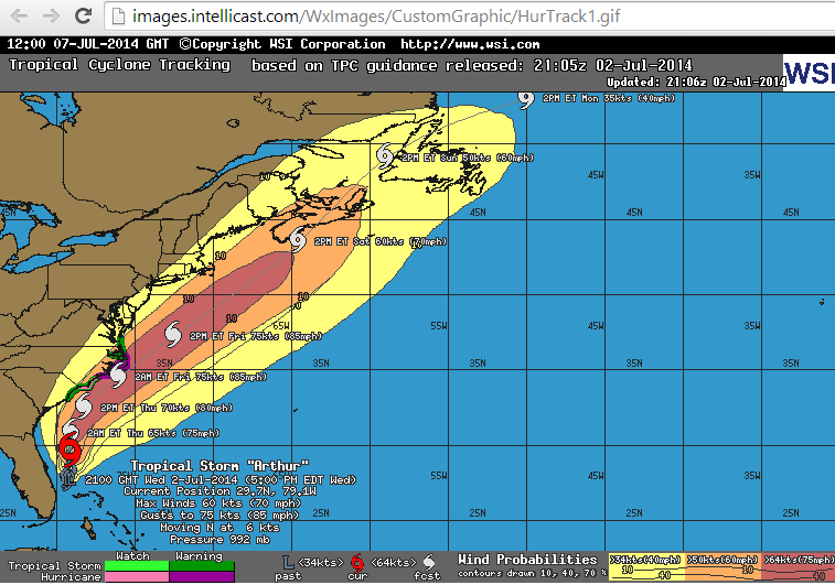
With Dry Air and all ..........Arthur became the earliest July Hurricane to hit the NC Coast...
(where's El Nino)

Good chart for tropical trouble from the weather system known as a hurricane ...that is not a dot.
IE.. Massive flooding up in CT and MA from storms spawned by Hurricane Arthur...
If you are in this shaded grid the NHC shows.. you might get "weather" from a hurricane.

See who was getting "weather" in the form of heavy, tropical downpours that flooded towns...
from Hurricane Arthur far off shore and to the South..
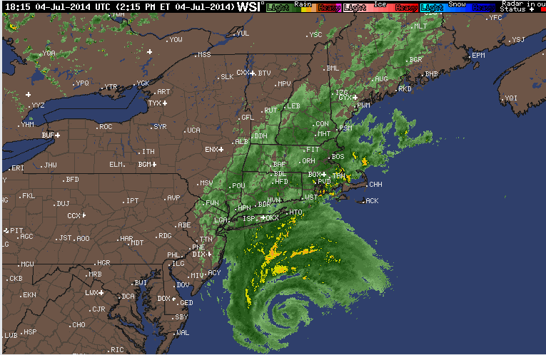
If we don't learn from history we are doomed to repeat it. Learn from it...
Besos Bobbi
Ps For Sue... El Nino where are you??
https://www.youtube.com/watch?v=mQfXPGCYlfI
posted by BobbiStorm @ 7:32 AM
![]()


0 Comments:
Post a Comment
<< Home