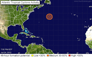
Orange Circle in North Atlantic & African Wave
I'm going to keep this short and easy...because the either the orange circle in the North Atlantic or the Near North Atlantic will die out or become some type of tropical storm... shame to waste the name Ernesto on that but who knows.
Here's another map of possible area's of tropical cyclone formation...
There is a beautiful wave off of Africa that is going to have a hard time staying together and models do not as yet support it. Note the big blue circle by the African Wave...
This is a real work in progress and will see what we see tomorrow with regard to what is still on the maps. Note, there is also a weak wave low down near South America that won't do anything big but it is there.
Models for the 40% Orange Circle:
One thing I do want to point out is the reason there is a system so far north with a 40% chance is because of the tremendous amount of tropical energy that is moving off of the Carolinas... look at this loop and see the bright orange flow east from Cape Hatteras? Normally the flow would be from the south moving WNW... not due East off of North and South Carolina ... but with the tremendous heat we are getting and rain storms every day... moving east, it is building up this energy that I do believe later in the season can become a problem.
http://tropic.ssec.wisc.edu/real-time/mimic-tpw/natl/anim/latest72hrs.gif
The flow on the bottom of the map above is NORMAL.. it's called the ITCZ and even with the dust there is moisture there flowing east to west... however..........the second orange line to the north is energy moving west to east ... that is not normal (though it is feeding the orange circle nicely) and nothing in between.
At some point.. something's got to give.
Keep watching.
Been busy with my daughter's wedding and travel arrangements and other things and honestly waiting all day to get a real feel for what if anything might happen ...models did show some small little burp of a storm up in the Atlantic or more so hinted at it.. let's see what the NHC hints at tomorrow.
Thanks for reading..
Besos Bobbi


0 Comments:
Post a Comment
<< Home