Miami Still in the Cone as Hurricane Rina Moves WNW @5 with 110 MPH

Tuesday Morning and Rina is still a Category 2 storm sitting neatly down in the Caribbean in a little pocket of warm water on the ledge of land North of Honduras and just east of Belize moving wnw at 5 mph. Slow, steady movement towards the tip of the Yucatan. She is just sort of swirling down there, dancing her way closer and closer towards those Mexican resorts. She doesn't seem to be in a hurry. Her slow progress is probably beginning to cause some upwelling which lowers the temperature of the water from VERY HOT to HOT to very warm. It could be there reason she has yet to become a Category 3 storm. She still has time though at the moment she seems bound to maintain her status vs a bout of rapid intensification.
Tell you one thing. The NHC took a long, long time before putting out their 11 AM Discussion. I waited on it before posting and rarely do they rarely wait until exactly 11AM to put it out. Basically, it is an update of their 5AM with some good discussion on why she might be weakening and leaving the door open to say that she might not. It's a hard call for anyone to really say just yet and a lot of people keep tuning in to see what's changed and the reality is not much has changed. She looks a bit ragged on the imagery according to one person, another person thinks she looks better on imagery. She has nudged a bit to the north and that was the main change...from due west to wow. The Cone looks the same, an extrapolation really of their 5am graphics package. Good discussion from Beven who does his job well and is enjoyable to read.
"The dynamical models forecast the ridges to the north and west to weaken during
the next 48-72 hours as a trough in the westerlies and associated
cold front move into the Gulf of Mexico. This evolution should
cause Rina to gradually turn northward near the East Coast of the
Yucatan Peninsula. The track guidance is in good agreement on this
part of the forecast...and the new forecast track is similar to the
old one."
I will say I have a problem with the timing. They have slowed down the forward progress of this storm a lot. And, in my mind IF she was catching the front she would move faster than the NHC has her moving. IF she doesn't catch the front... I don't see her getting that far into the Florida Straits unless the front bombs out.... so that is my real question here. Why get her that far north and then move what seems to be due East when the discussion has been that the front would move down into Cuba...in which case she would not be going due East at 7am on Monday. I am sure that it makes sense to people who know a lot more than I do and they are again averaging out models and extrapolating and they have to answer to a much larger audience than I have here but that is my problem with the current cone.
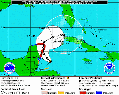
I'm still in the Cone Zone in the northern part of the bubble.
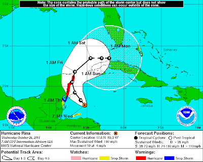
Actually, when you consider how many really excellent waves were unable to come together earlier in the season to even Category 1 status what she is doing down there is pretty amazing.
Official wording shows that the NHC most likely believes she will be more like Floyd from 87 and NOT like the Wilma that we remember vividly in South Florida. Note how similar the two forecasts are that call for South Florida to have stormy weather but not hurricane weather.
Text from the NHC Discussion this morning:
AND THE OFFICIAL FORECAST...SHOW
SIGNIFICANT WEAKENING IN THAT TIME FRAME. THEREFORE THE OFFICIAL
TRACK FORECAST...LIKE THE PREVIOUS ONE...SHOWS ONLY A SLOW EASTWARD
MOTION NEAR THE END OF THE PERIOD. THIS IS REASONABLY CLOSE TO THE
LATEST GFS TRACK. IT IS WORTH REPEATING THAT THERE IS GREAT
UNCERTAINTY AS TO WHERE RINA WILL BE LOCATED BY THE WEEKEND.
Text from Miami Marine Forecast:
FRONT THAT MOVES OFF THE TEXAS COAST LATE THU AFTERNOON OR
EARLY EVENING. THE FRONT WILL QUICKLY REACH FROM THE FLORIDA
BIG BEND TO THE E BAY OF CAMPECHE FRI NIGHT THEN BEGIN TO
INTERACT WITH HURRICANE RINA CURRENTLY IN THE NW CARIBBEAN
SEA. RINA IS FORECAST TO MOVE TO 20.5N 87.0W THU
AFTERNOON...THEN BEGIN TO WEAKEN AND TURN NE TO NEAR 21.8N
86.6W LATE THU NIGHT...23.5N84.5W LATE FRI NIGHT...THEN TURN E
AND WEAKEN TO A TROPICAL STORM NEAR 23.5N 83.0W LATE SAT...AND
23.5N82W LATE SUN.
Models are similar but still split on whether she is able to withstand the Cold Front that will move down into the Gulf creating tremendous shear and which may blow her apart or whether she will just bobble around down there and stay on the maps for weeks down the road. Could she really do a small little loop, fall apart and then reform strong again down in the Caribbean vs zooming NE towards and across Florida? Waiting to see this drama play out.
Sort of like life. Somethings in life you just can't rush. You have to wait and see how they turn out. And, while you are waiting may I suggest listening to some good music, sipping some good espresso and enjoying the feel of balmy, breezes off of Biscayne Bay. Now, if you are reading this from Houston or Hungary then find a spot where you love to delight and enjoy some delicacy and check back later.
Models at 11 pm last night are not very different from models at 5 am. Still an either or scenario.
11PM

5AM
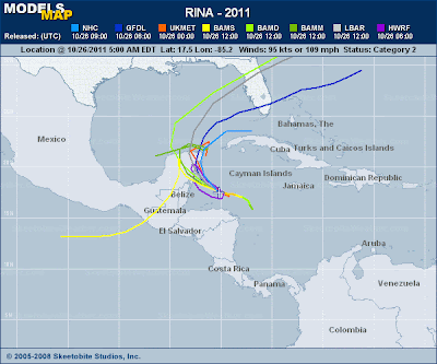
Note the NHC seems hard pressed to decide which has a better handle on Rina...the GFDL or the HWRF. Note none of the models have her dying out where the NHC shows her coming to a halt. The HWRF shows her diving south as a reaction to the high from the cold front which doesn't grab her. That would be a temporary movement and if she maintained herself she could regroup later as that cold high air will only be a temporary thing in the land down under. The GFDL has her predictably getting caught up in the cold front and zooming across South Florida out into the Atlantic. Now...which is more logical and more in step with climo for an October storm? Another question...is this an October storm or a November storm in October. IF she is a November storm
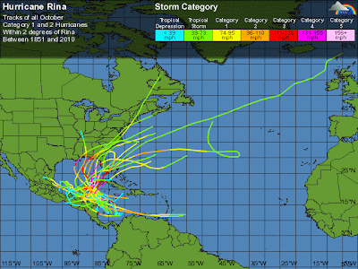
My brother wants to know how we are supposed to believe the forecast when they have been wrong with this storm already a few times. A lot of "IFS" in the forecast. IF it hits the mountains in Cuba... IF it doesn't catch the front... IF it stays in the Passage... a lot of IFS. We are basically waiting to see how much shear really builds up and how it affects her. If we are already into November from a Climo perspective she will sit down there and not catch the front and do weird kinky things. IF she is a true October system she will grab the front the way the GFDL shows and we will see a US landfall.
October Storms:
Snow in Denver:
http://www.youtube.com/watch?v=VVwwp3sXAro&feature=youtu.be
As for me... I'm going in the shower and then going to go about my day peeking back and forth to see just what if anything has changed. Been fun learning how to use an Apple from one of the best teachers around with hands on experience while I sit here waiting and watching and enjoying the Cafe Con Leche and the tropical breezes in the backyard.
I will say one thing. We took a walk last night not the Boardwalk in Hollywood and the breeze was really strong. Almost chilly and it swung around out of the north from an onshore wind for a bit and I thought it reflected well the battle going on in the Modelsphere as we have definitely gone zonal and cold fronts are sprinkling snow early this winter. Easy to say that the cold front might not grab her but if she stays down there....well things spin up on the edge of old frontal boundaries all the time which would lead me to believe she would only be playing possum down there waiting to spin up again should she not take the easy road out of the tropics. As always, time will tell...
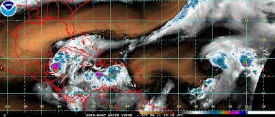
Will end this with the thought that Rina is a storm that sits in a small pocket of tropical air above warm water and is able to continue maintaining her strength despite everything else going on around her. To the north there is dry air, there is shear nearby and yet she keeps on spinning at Category 2 strength. She might make it to Cat 3, she might not. She will eventually slow down and diminish in intensity. But..... unlike other weaker waves that could not become a hurricane this season, she is doing her thing even if it is in a small corner of the warm Caribbean. Don't count her out. Will she be Wilma or go flat like Floyd? I don't know for sure though the NHC seems to think she will fall apart past like Floyd once the big bad cold front from the north moves her way.
Leaving you with a video of my daughter Dina hooping in her small, but very cute kitchen. I get nervous when she does it in my living room... I suppose I should not worry because if she can hoop in her cute, little kitchen which is about the size of Holly Golightly's kitchen I suppose she can hoop anywhere .... and so can Rina for a while.
http://www.youtube.com/watch?v=WIja0juvlnI&feature=colike
Besos Bobbi ;)
Ps...note that is my term Modelsphere. I want credit for it!


0 Comments:
Post a Comment
<< Home