Maria, Nate and Katia & Inland Flooding in the US

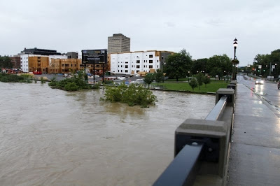
The story of the day really is the inland flooding far from all 3 of these tropical systems that was caused by a mix of the remnants of Lee and the trough that picked up Lee and the tropical dance they did of Caribbean Infusion into a frontal boundary moving through the Mid-Atlantic.
Long sentence to explain that the rain from Lee intensified the amount of moisture and created a tragic scenario that without Lee's remnants would just have been another day of September Rain.
This is directly tied to Lee and it should be a lesson that hopefully many will remember that what happens on the coast of Louisiana can and might effect those living in upstate NY. Lee's butterflies wings were really powerful and devastating. Another reminder that weak tropical systems, tropical storms especially can sometimes cause much wider misery than a small, compact, strong category 1 or 2 hurricane.
It's interesting for me to see the city of Binghamton being covered live on air as I have had many friends in Chabad who were mostly macrobiotics who went to school there years back. There's a big university and a wonderful community that is being impacted today from flooding on the levels the NE has not seen since Agnes. Pennsylvania, Maryland and the later today NYC and New England again will get socked. The legacy of Lee.
I'll say it again and again and again and I discussed it with Bill Read at the NHC during a conference there, always bothers me... inland flooding does not generate the pre-storm hype that landfall does and that needs to be changed. It's something about the way the NWS works, they work in real time. They put it in the long range forecast "watch Lee" but they don't get the attention even locally that the NHC does far away. This really MUST change as conditions locally often happen faster in real time and are more prone to change quicker than a 3 day cone out of the NHC. The NWS's loss was the NHC gain when Bill Read moved to Miami to work for the NHC. I only wish the media paid more attention to inland flooding possibilities before the horse swims through the barn door.
http://www.pressconnects.com/article/20110908/NEWS01/110908025/
Video-from-BU-Event-Center-evacuation-center?odyssey=tab|topnews|img|FRONTPAGE
http://www.pressconnects.com/
In the tropics Maria keeps moving west and it's not a good thing that she is not intensifying, because the weaker she stays the more she moves west. The more chance she will impact land and affect the islands.
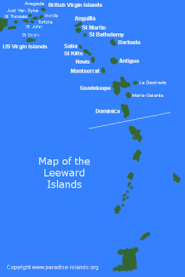
At 8 AM the French Islands issued a Tropical Storm Watch for their part of the world. They do their own excellent forecasting and they are very proactive in their watches vs some of the other wait and watch and see attitudes in the Caribbean.
TROPICAL STORM MARIA TROPICAL CYCLONE UPDATE
NWS NATIONAL HURRICANE CENTER MIAMI FL AL142011
800 AM AST THU SEP 08 2011
THE GOVERNMENT OF FRANCE HAS ISSUED A TROPICAL STORM WATCH FOR
MARTINIQUE...GUADELOUPE...ST BARTHELEMY AND ST MARTEEN.

The salient point here is not how strong Maria is now, or if she does or doesn't have a closed circulation as the NHC is implying (boy would they love to downgrade her) but what she will do tomorrow. A weak, insipid upper level low has been moving out ahead of her and keeping her development in check the last few days. That is expected to move away and leave Maria in a position to strengthen in a few days when she is much closer to the islands. Until then, she is going to ride the southern edge of the Atlantic high and keep moving west. Many a storm has had this set up and often when the upper level low gets out of it's way it intensifies rapidly. This worries me more than if Maria was getting stronger and pulling north more. With every new advisory you will see her cone moved further and further west. More an Emily scenario than her sisters Irene and Katia in that she is developing slower and having problems pulling it together and if so she may come in further west than both Irene and Katia. BUT, she should miss the United States and curve north like Irene and Katia before her.
NOTE.... at some point this scenario is going to change and as we still have storms coming off of Africa, this is not a lock on future forecasted tracks. It is what it is today in early September, late September may be a different set up as things become more fluid later as we approach Autumn, true Autumn not meteorological Autumn which started on September 1st, the real autumn when fronts dip down more and sometimes the door to the north gets blocked by ridging that moves in deep after a cold front moves off the east coast further south.
So stay tuned as Ophelia is waiting in the wings, probably in the form of a Cape Verde Wave that recently exited the African Coast.

The Good News with Nate is the door is opening for a possible northward track towards Texas. The BAD NEWS is that if he goes too far east he could hit the same area Lee did and cause the same trouble Lee did. Right now, if this was a Magic 8 Ball it would read "Try Again Later" as there are just too many possible scenarios even though the NHC is officially going with the shuffle off to Mexico track.
Stay tuned and contribute generously to the Red Cross or any charity of your choice in the affected areas as the natural disasters of 2011 just keep rolling in... if only money and charity could roll in as fast to help the survivors of this messy weather year which will go down in history for record rainfall and record floods after a winter that didn't stop with record snowfall. Beginning to make me wonder what this coming winter will bring up north and how fast it will or won't come on.
But, hey that's Bastardi's territory not mine, I just follow the tropics.
Besos Bobbi
Ps... Last night while watching TWC after the debate, one of the on air meteorologists said and I quote "The flash flooding happened really suddenly" and I just stared... she's not Stephanie Abrams or Jim Cantore, that's for sure... yup, that's why they call it "flash flooding" . . .


0 Comments:
Post a Comment
<< Home