What to do about "Nicole" ???

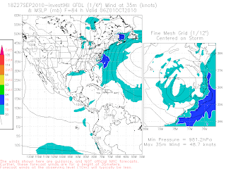
It's a problem... there is a system down there that looks to be slowly developing while a steering pattern is developing that would move it north faster than a speeding bullet.
How do you make a forecast for a fast moving "something" that has not yet developed even though the pattern and models scream the name Nicole?
Not a nasty Nicole wind strength wise but a very, very wet Nicole moving North or NNE over an area that is already water logged and not totally prepared or sure what they are getting?
Models:
http://moe.met.fsu.edu/cgi-bin/gfdltc2.cgi?time=2010092718-invest96l&field=Sea+Level+Pressure&hour=Animation
Takes it from FLL to JFK in record time... could that verify? Looks like Nicole has a seat on JetBlue...
This is basically where the rain would go but of course does not give it a name or definition... just it is what is logic... a lot of rain.

NWS Miami:
".DISCUSSION...MAIN FOCUS OF THE FORECAST CONTINUES TO BE ON THE
DEVELOPING WEATHER SITUATION EXPECTED TO UNFOLD TUE-WED WITH THE
MAIN IMPACT EXPECTED TO BE THE POTENTIAL FOR FLOODING...POSSIBLY
SIGNIFICANT. LOW PRESSURE OVER THE WESTERN CARIBBEAN WILL MOVE
TOWARDS WESTERN CUBA TUESDAY...THEN ACROSS SOUTH FL ON WEDNESDAY.
THERE IS THE POTENTIAL FOR THE LOW TO DEVELOP INTO A TROPICAL
CYCLONE...THOUGH INDICATIONS ARE THAT ANY DEVELOPMENT WOULD BE
SLOW TO OCCUR.
REGARDLESS OF TC DEVELOPMENT...COPIUS TROPICAL MOISTURE WILL SURGE
NORTHWARD INTO THE SERVICE AREA TONIGHT-TUE...REMAINING IN PLACE
ON WED AS THE LOW MOVES ACROSS THE AREA. THE DEEP MOISTURE WILL
LIKELY MOVE TO OUR EAST BY THU."
This caught my attention as I will be up there for the Jewish Holiday of
Simchas Torah that may be very soggy this year....

So...going to wait and see what they say later tonight.
They can put up urban flood advisories and they can talk on probabilities and the front can out run the developing storm (possible) and either way South Florida is in for massive messy rains and possibly strong winds between the possible Nicole and wind gradient and front and there is very cool air here coming in my window. Watching Monday Night Football. Restless. Very, very restless. Not a good sign and wondering if that's a tropical thing or Just Bobbi??
Still raining up here.
NHC is holding steady at 40% chances... light orange...
Only time will tell.... but by tomorrow morning they will have to say something definitive beyond 60%.
A lot depends on "where" she forms because she could just as easily pull to the right (east) and stay offshore South Florida... never know. Seems all that talk of Tampa getting hit is Gone With the Wind... maybe once again Ft Myers gets lucky...

Sweet Tropical Dreams
Smilin Bobbi ;)


0 Comments:
Post a Comment
<< Home