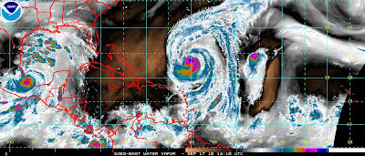
Hurricane Karl Makes Landfall as a Major Cane... Bermuda in the Crosshairs for Igor ... Reminder 1926 Miami Hurricane

I want to make a few fast points here before moving on to chores I have for the rest of the day.
1. The season is far from over and the patterns set so far will not continue as the weather patterns change and we move towards October. If you live along the Gulf Coast or in Florida, anywhere in Florida or the Carolinas please stay on top of the your game and do not think it's over and the Fat Lady has sung and start devouring your hurricane supplies (goodies) as you may seriously need them later on this season. We have a pattern, it's called Tex/Mex and Bermuda... that is based on current conditions in the atmosphere and they are and will be changing. What will not change is that storms will continue to form and ramp up fast and the next storm or the one after that might ramp up fast just off shore or where it will hit.
2. The NHC has been almost picture perfect with track this year... they have come as close to sucking as they can get on Intensity forecast. Sorry, but as an old friend Aggease used to say... I call em as I see em... Storms have been forecast to fall apart that became Category Fours. Karl did not make landfall as a Category One but as a Major Cane and Earl for all his press releases did not make landfall as a Category 3 or 4 on the Outer Banks. I pray... that they are wrong with Igor and he as dramatically weakens before hitting Bermuda as Bermuda is in the middle of the cone less than 3 days out...that is as perfect as you can get for a prediction of a landfall. It's a small dot in the ocean, hoping Igor has mercy and moves a bit left or right and saves them from a direct hit but they will get prolonged hurricane conditions for some time as he is a large, lumbering, slow moving storm.. let us hope he weakens as did Earl.

3. This weekend is the 84th Anniversary of the Great Miami Hurricane of 1926.. a storm that slammed into Miami in a similar year which featured multiple Category Four storms... and a similar sort of high but one that was placed a little closer to shore and to Florida and Cuba who both took a historic hit. What people do not remember is that Florida got him in October.. again with a storm that came up out of the Caribbean as Hurricanes are want to do in October.

What if we thought we were getting a medium size Category 1 and in less than 24 hours as it was crossing the Gulf stream it hit as a Category 4?? Also, notice patterns... flooding in Iowa in 1926... Category 4 Hurricanes. Respect the past... learn from it.

So.... leave those Twinkies and fruity punch drinks in the Hurricane Locker and keep them locked up until December 1st. If you need anything that you did not get... get it.
That's pretty much it ...except to say that the storm that hit NY last night was responsible for at least one death as a car fell on a tree with a lady inside... the damage total will be crazy and some apartment buildings in Queens had the roof ripped off of them as if a can open came down from the dark, heavens and peeled it right off. Hard to believe that is not a tornado signature and just "straight line winds" but time will tell.
As for telling...Karl is making landfall as a MAJOR Cane... that became Major in less than 24 hours... fast moving, fast intensifying and a fast lesson for all of us thinking things like that just don't happen. They do...
Besos Bobbi.... My beautiful Myami below as she sits today, so close to the waterline, so beautiful...a real picture taken by my brother just a few weeks ago.


1 Comments:
Lovely shot of Miami, Bobbi. And you are right on where intensity forecasting is concerned. And I think that is what worries most of us because Emergency folks encourage people to stay and ride it out if they are not in an evacuation zone. And that evac zone is highly dependent on the intensity forecast.
It is the reason we have always left with a call for voluntary evac of Level A even though we are in a Level C zone here in Tarpon Springs. Yet we have neighbors whom we know will not leave.
Post a Comment
<< Home