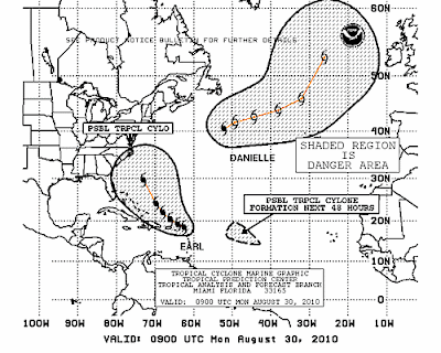
Intensifying, Mystifying Earl

Earl is intensifying while he plays down in the Virgin Islands about to take a Jetblue flight for the NE, with a possible stop in Wilmington or some airport that Jetblue serves in that area. Possible stop I said.
He has been consistently left of forecast .... left of every forecast.
The Virgin Islands and the other islands that it was supposed to pass to the right of are now getting Earl. Great loop from yesterday that a friend sent me of yesterday's movement towards the islands. Shows how it got further west than forecast.
http://einstein.atmos.colostate.edu/~mcnoldy/tropics/earl10/Earl_29Aug10.gif
As they said themselves there is low confidence in their long term forecast that can be off by up to 300 miles or so as stated in their 5 AM Discussion. See below:
THIS IS A GOOD TIME TO REMIND EVERYONE THAT NHC AVERAGE TRACK
FORECAST ERRORS ARE 200 TO 300 MILES AT DAYS 4 AND 5. GIVEN THIS
UNCERTAINTY...IT IS TOO SOON TO DETERMINE WHAT...IF ANY...PARTS OF
THE U.S. EAST COAST MIGHT SEE DIRECT IMPACTS FROM EARL LATER THIS
WEEK.
The picture above is the Virgin Islands being affected by Earl.
Since the NHC themselves feels they cannot trust their own forecast right now out beyond 3 days I am going to use for Earl their 1 2 3 chart below.

EVERYONE in the NE should pay close attention to this storm from NY to Cape Cod and I don't mean Long Island I mean NY, the NYC metro area as well. Maybe even Cape May north...
Why? Strong storms at that lat move very, very fast and can get from point A to point B while you are sleeping.
The VI had little time to deal with a Hurricane Warning, as they upgraded the watch at the last minute. True...they were told to watch but a big difference between a "watch" and a "warning" in people's minds who are used to hurricanes being watched.
Will post more after the 11 am.
On a personal level I was at the beach yesterday... didn't see the big waves that I heard about tho the undertow was wicked. Didn't take that many pics, was not something to take pics of as much as to enjoy and feel, walked ankle deep in water and got slammed by low rollers up to my knees.... heavy strong surf and the water was VERY VERY VERY Warm for the Outer Banks... VERY. Mostly I kept thinking this would supply strong fuel for a major Cane. So, a bit sunburned and catching up to speed in the world of loops... thank you so much everyone who kept feeding me what the loops were showing ;) and was a fun drive...
Besos Bobbi
Ps Fiona should start to get her name later today and use http://www.stormcarib.com/ as your guide for the next few hours for the best reports from the locals, they do a fantastic job!


1 Comments:
Wow that's scary how different the official forecast is and the 1 2 3 chart. Especially considering how far left of forecast earl. Has been consistently
Post a Comment
<< Home