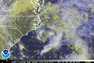
Lunch Time Update on 91L .. System off Carolinas

Okay... fast little update here on my lunch break.
The NHC is issuing "Special Tropical Weather Outlooks" on it and has given it a yellow as 30% chance currently. Stay tuned for more updates. The dream team over at the NHC has posted this info:
"AN AREA OF LOW PRESSURE ACCOMPANIED BY A FEW SHOWERS IS LOCATED
ABOUT 120 MILES SOUTH OF CAPE HATTERAS NORTH CAROLINA. WHILE
CONDITIONS ARE NOT FAVORABLE FOR SIGNIFICANT DEVELOPMENT...THE
SYSTEM HAS A BRIEF OPPORTUNITY TO BECOME A TROPICAL CYCLONE BEFORE
REACHING THE COLDER OCEAN TEMPERATURES NORTH OF THE CAROLINAS. AS
THE AREA OF LOW PRESSURE MOVES TOWARD THE NORTH AT 10-15 MPH...THE
SYSTEM COULD BRING SOME SHOWERS TO COASTAL NORTH CAROLINA LATER
TODAY. THERE IS A LOW CHANCE...LESS THAN 30 PERCENT...OF THIS
SYSTEM BECOMING A TROPICAL CYCLONE DURING THE NEXT 48 HOURS. AN
AIR FORCE RECONNAISSANCE AIRCRAFT WILL INVESTIGATE THE SYSTEM THIS
AFTERNOON...IF NECESSARY...AND AN ADDITIONAL SPECIAL TROPICAL
WEATHER OUTLOOK WILL BE ISSUED AT 2 PM EDT. SEE LOCAL WEATHER
FORECAST OFFICE PRODUCTS FOR ADDITIONAL INFORMATION.
$$
FORECASTER LANDSEA/FRANKLIN"
So...there you go ... keep watching because they are watching and well ..it's still a bit close to the coast even if most models take it out to sea.. the GFDL the favored child of the set takes it up through the Nags Head area and if that would pan out I would expect to see one of the TWC people out there looking seriously wind blown.
Maybe... gotta run before I get caught in the rain here.. and it washes out my lunchtime walk.
Nice loop, very closed, neat system depending on which satellite you look at..
http://www.ssd.noaa.gov/goes/flt/t1/loop-rgb.html


0 Comments:
Post a Comment
<< Home