Gustav - Pressure Rises.. Pray it's a Good Sign

Probably the best visual translation of the NHC's cone of what area might be most affected by Gustav..thank you Skeetobite..

Lightning in the eyewall, interesting observation made on TWC. Though not uncommon it is a good observation.
Reports from the hurricane recon plane have shown a leveling off of pressure and a few slight rises in pressure though that may be a temporary change and not long lasting. Also, the eye wall has some strange abnormalities compared to most storms of this intensity. And, yet.. it seems to work for Gustav.
From recent advisory from NHC:
"Gustav is moving toward the northwest near 16 mph...26 km/hr...and
this motion is expected to continue prior to landfall. On the
forecast track...the center of Gustav would reach the northern Gulf
Coast during the daylight hours tomorrow. A decrease in forward
speed is expected to occur on Tuesday."
15,000 people have thankfully left New Orleans and a tremendous amount of people in the Gulf Coast beyond any figures I have that have thankfully evacuated.
115 mph
NW 17
This storm has just made a beeline for this area as if it had been pre-programmed from the start. It's like some interactive video game where someone put in the cords and it refuses to budge. The forecasted track shows it might slow down and veer just a bit to the left but that's a maybe... and nothing is a lock.
Stay safe is all I can say and hope that the prayers of many have helped in some way to keep this storm from intensifying.
Flooding inland will be huge and it's impact will be huge as well so do not think that just the coastline will suffer the effects from Gustav. The area to the west of Nola is low lying rice country, bayou... pray it hits an area lightly populated and does the least damage as possible.
As for the impact on oil.. only time will tell on this one. So many oil refineries in it's path... might be a problem.. you think?
The best thing this storm can do is pick a point and move in fast vs slowly edging along the coastline as the cone shows a possibility.
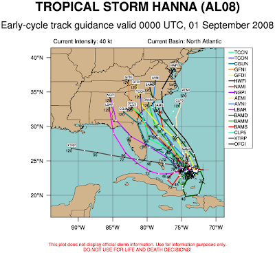
As for Hanna.. she has begun a slow intensification process tonight. She might not look like much but her convection is centered and deepening. Her models are all over the place. This storm needs a shrink. Do not rely on any path for a day or so when it finds its grove and really ramps up and develops into something more than messy convection and a misplaced center. That might be happening tonight.. maybe. I think the ULL that was bothering Hanna has finally died and she might be flying on her own.

As for Invest 97.. it's near depression status far to the east near Africa.
An excellent job of evacuation and early warning by the governments involved and the National Hurricane Center.
Prayers for everyone.
Keep watching to see if the pressure rises indicate that he is not going to get any stronger and it isn't some other process.
Thankfully, we live in a world where we can be warned and issued watches and given time to prepare, evacuate or hunker down and that is a world away from towns that were wiped off the map in this area in the 1700s and 1800s. We have come a long way in hurricane warnings and preparation. We have much to learn but we should all stop and give thanks for how much we know and the excellent job that the NHC does in helping us stay alive and prepare properly for these catastrophic events.
Night.. all my prayers... Bobbi
Bonus pic... what is next to deal with after the landfall and aftermath of Gustav. Hanna...


1 Comments:
Honestly- I could not help looking back at a wee bit more...Hannah needed a shrink???
Ok, back to work/sleep/work..ta ta till later today or this morning, busy busy day!
Post a Comment
<< Home