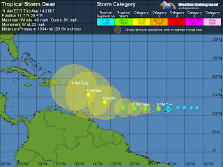
Tropical Storm Dean Forms.. Moving Fast West

Okay, this will be a short post this morning. I waited til the official upgrade to post.
As I said yesterday, the storm is staying on the left side of the forecasted track (SOUTH) and it is moving FASTER than previously predicted and they have now put it at 23mph forward speed.
There is a doorway for it to recurve or pull more to the right/north in the Atlantic but that door which is an upper level low is almost due north of it right now. If it would be going slower it would easier to catch that doorway.
My worry.. if it moves so fast and the upper level low forms near puerto rico that will draw Dean further west into the Carib and Florida and the SE coast is more under the gun.
If you go to www.wunderground.com what you will see is a map of the United States. See the cold front draped across the deep south (alabama/miss/joja)? See the other one above it that caused wild weather last night in Minnesotta? There is no way those fronts will not keep coming and pull on Dean eventually. But... any recurvature I fear will be too late for Fla/SE Coast.
Of course unless it just keeps going west.. but then there is the next storm forming in the Gulf right now.
A very messy mix of models.
Posting two below FOR ENTERTAINMENT PURPOSES ONLY... as they are still far out.
One shows..poor, poor, Puerto Rico being feasted on by a Major Killer Dean... hopefully that will change in future model runs.
The other is the earlier GFS run that probably made the NHC and a lot of people in Miami blink.. shows a direct hit on south florida, give or take which city.
More models will show more possible tracks until there is some concensus they can agree with...
My guess which is really early on and not trusting in too much would be it will affect Puerto Rico in some way and maybe if it feels a wnw tug.. scrap across the top half of Haiti... that front is there and I would like to convince myself it will go south of Hispanola and through the islands but... doubt it. Would be wishful thinking and I am not a wishcaster..
Stay tuned..
http://www.nco.ncep.noaa.gov/pmb/nwprod/analysis/carib/gfs
/06/index_pcp_s_loop.shtml
it's hard to see it but under that storm would be poor poor puerto rico http://www.nco.ncep.noaa.gov/pmb/nwprod/analysis/
hwrf_nested/storm_2/06/images/hwrf_pcp_126l


0 Comments:
Post a Comment
<< Home