Will the NHC Blink? Special Statement Issued
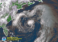
This is an old picture of subtropical storm Ana:

This is a link to an image of the system off the coast of the Carolinas currently referred to as NON-Tropical Low
http://www.ssd.noaa.gov/goes/flt/t1/vis.jpg
WATCH LOOP of current Non-Tropical Low spinning off the coast:
http://adds.aviationweather.gov/satellite/displaySat.php?region=TPA&isingle=mult_big&itype=vis
I don't understand why it is not considered a sub-tropical. But, then I only studied meteorology and oceanography briefly for my degree in International Relations.. weather matters when working with world politics. Ask Lex .. he knew.
So, anyway.........
I have been watching (though staring would be the proper word) the amazing low that has been called a coastal low, a nontropical low and a cut off low .. anything but a subtropical low for the last few days.
Anyone who knows me knows I like to call a spade a spade, a duck a duck and not play make believe games with high falluting language to explain away why something isn't what you see it is.. what you know it is..
This is in my opinion... just mine and a lot of other people I trust... a subtropical storm at the very least.. definitely trying to cross over into a hybrid..
It deserves respect, it deserves a name, it deserves attention and advisories.
And.. more so the SE Coastal cities deserve respect.
A High Wind advisory with words about hurricane force winds do not cut the mustard.. sorry.
This isn't the NWS (National Weather Service for someone who surfed in here) but the NHC.. National Hurricane Center. And, if a storm is producing hurricane force winds in the subtropics and has cut itself off from whatever system spew it forth and it is spinning wildly just off shore and headed towards the coast there needs to be attention, advisories and yes.. even to some degree media attention even if it comes off as hype.
People need to know.
The Navy knows, they have an invest up:
http://www.nrlmry.navy.mil/tc_pages/tc_home.html
People on message boards on HurricaneCity.com and Flhurricane.com know..and other boards.
Heck my brother Ronnie sent me some link to a board even I never heard of..
So..now that the Special Statement has been issued today and yesterday they sent out a check of their Seahorse system of email advisories they send out... will be get Andrea a bit early this year?
I would think so. Not my call ... not anyone's call but the NHC but my inquiringly, curious mind wants to know why wouldn't you issue a Subtropical Storm Advisory for this system which is a whole lot closer than Ana was out by Bermuda and likely to cause real damage somewhere here a long the Florida/GA coast.
Wiki has a great write up on Ana from April of 2003..
How is this not like Ana? I don't know.
wiki:
http://en.wikipedia.org/wiki/Tropical_Storm_Ana_(2003)
Will out NON-Tropical become Andrea?
There never seems to be any good rule of thumb for when a system gets a name as a subtropical and when it doesn't.. someone has to make that call and that would be the NHC.
Oh LOOK! A Special Statement from the NHC..
Are they blinking?
Only time will tell.
Welcome to the real world of the National Hurricane Center Mr. Bill Proenza, how do you like it now?
"DSAAT
SPECIAL TROPICAL DISTURBANCE STATEMENT
NWS TPC/NATIONAL HURRICANE CENTER MIAMI FL
950 AM EDT TUE MAY 8 2007
A NON-TROPICAL LOW PRESSURE SYSTEM...CENTERED ABOUT 230 MILES
EAST-SOUTHEAST OF THE GEORGIA AND SOUTH CAROLINA COASTS...HAS BEEN
MOVING SLOWLY WESTWARD AT 5 TO 10 MPH. THIS SYSTEM IS PRODUCING
GALE-FORCE WINDS AND HEAVY SURF ALONG THE COASTS OF NORTH
CAROLINA...SOUTH CAROLINA...AND GEORGIA...WITH STRONGER WINDS
OFFSHORE. ASSOCIATED SHOWER ACTIVITY HAS INCREASED SINCE
YESTERDAY...BUT NO SIGNIFICANT STRENGTHENING OF THIS SYSTEM IS
EXPECTED. THE LOW IS BEING MONITORED FOR SIGNS OF TROPICAL OR
SUBTROPICAL CYCLONE DEVELOPMENT...AND AN AIR FORCE RESERVE
RECONNAISSANCE AIRCRAFT WILL BE AVAILABLE TO INVESTIGATE THE SYSTEM
TOMORROW MORNING...IF NECESSARY.
INTERESTS ALONG THE COAST OF THE SOUTHEASTERN UNITED STATES SHOULD
MONITOR PRODUCTS ISSUED BY LOCAL NATIONAL WEATHER SERVICE FORECAST
OFFICES. ADDITIONAL INFORMATION ON THIS SYSTEM CAN ALSO BE FOUND
IN HIGH SEAS FORECASTS ISSUED BY THE NATIONAL WEATHER
SERVICE...UNDER AWIPS HEADER NFDHSFAT1 AND WMO HEADER FZNT01 KWBC.
$$
FORECASTER KNABB
Stay tuned.. developing, just off the coast and possibly coming to a theatre near you if you be living in Savannah or Jacksonville or anywhere in between.
Bobbi.. going back to staring mode..
http://adds.aviationweather.gov/satellite/displaySat.php?region=TPA&isingle=mult_big&itype=vis


0 Comments:
Post a Comment
<< Home