Is Barry Brewing In The Tropics? Model Links

Okay, so we are watching a system down in the Caribbean slowy brewing and possibly coming together.
The NHC issued a Tropical Disturbance Statement throwing in their hat to a ring as has the Navy with their NRL Invest of the area.
http://www.nhc.noaa.gov/text/refresh/MIADSAAT+shtml/311549.shtml?
salient point: ALTHOUGH THIS SYSTEM HAS SOME POTENTIAL FOR
TROPICAL DEVELOPMENT OVER THE NEXT DAY OR SO...THE LOW IS EXPECTED
TO MOVE SLOWLY NORTHWARD INTO THE SOUTHERN GULF OF MEXICO WHERE
ENVIRONMENTAL CONDITIONS WOULD LIKELY FAVOR FURTHER DEVELOPMENT AS
A NON-TROPICAL LOW. REGARDLESS OF DEVELOPMENT...THIS SYSTEM SHOULD
BRING HEAVY RAINS ACROSS WESTERN CUBA AND SOUTHERN FLORIDA OVER THE
NEXT COUPLE OF DAYS.
They don't mention here that there is a probability that they will be sending planes in as needed tomorrow morning. There is a plan of the day if it is needed: http://www.nhc.noaa.gov/text/MIAREPRPD.shtml?
So... we watch, we wait.
We talk of how it looks a lot like Arlene did in 2005 and I think personally this little rainmaker can be more like Irene whose "weather center" went ne up into the Miami area even though the low pressure center sort of went up the west coast of Florida where Jim Cantore stood around in barely any wind or surf waiting while the SE coast of South Florida got swamped with flooding rains and high winds. Personally, SW Florida can use all the rain it can get.. hate to steal theirs.
Time will tell as always and the Recon will seal the deal as usually the NHC waits to get the best view of the storm up close and personal.. their little dropsondes dropping down into the area to give us a better picture of the pressures, windspeeds and such.
Would be a great kick off for the 2007 season to have a storm named on Day One. If that doesn't force Floridian's to go out and buy their hurricane supplies early and take advantage of the tax free week..nothing will.
Early models are linked below. Pay attention to Skeetobite.. he is as good as it gets when it comes to this stuff even though there are a ton of sites offering possible model tracks online.
http://www.skeetobiteweather.com/picservice.asp?t=m&m=92
Freebie Link of the day.. for those of you who do not have a grocery store or gas station giving out hurricane maps you can print out a chart from this link.. and track away.
http://www.nhc.noaa.gov/pdf/AT_Track_chart2.20060925.pdf
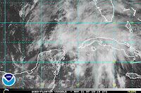
What might be Barry is barely visible right now on visible imagery but come tomorrow.. might be a different story.
http://www.ssd.noaa.gov/goes/flt/t2/loop-vis.html
My thought? Bobbi's Bottom Line?
I wouldn't have given it much of a thought this morning but it really is trying to pull itself together. There is a sort of curvature and even some early banding sort of structure which makes it sure look like it's trying to form. It needs to fear the shear if you ask me.. if it can get past the shear and consolidate around that little center... we might have Barry Brewing in the Tropics.
...oh come on.. sounds so good doesn't it? Barry Brewing the Breakfast Blend at Starbucks? Will the morning see NHC issuing advisories?
Stay Tune .. Developing.......


0 Comments:
Post a Comment
<< Home