Links.. Enjoy ... a few thoughts
My 13 year old daughter is looking at Katrina twist and turn and says in amazement, "Wow, she is so beautiful. To think we knew her when she was young!" Oh yeah, my kids are hooked. Miami kids.. they don't know nothing about earthquakes but they know what to do if a storm is headed this way. And, may I add here that the local radar has showers going fast through our area from the south.. bands wrapping around Katrina..so far away. So..here are some links: Enjoy them.. play with them and I'll keep trying to post them though I keep getting lost in discussion or staring at some new link someone sends me. Story posted on message board. Have worried on this and have heard the debates. It's a sort of you are damned if you do and damned if you don't. You have to provide shelter. What if they get only a Cat 3 and it veers away or diminishes in strength and people get killed because there was no shelter at all? Better there than in a one room apartment on ground floor on Canal Street..
http://www.wwltv.com/local/stories/wwl092304thanh.1295648.html
water vapor look up close for people who love to stare into the eye of a storm
beautiful big wide image
http://www.esl.lsu.edu/special_gifs/trop_lant4col.jpg
link to live coverage on TV http://www.wwltv.com/perl/common/video/wmPlayer.pl?title=beloint_wwltv&props=livenoad
For anyone who really understands weather this is more exciting and scarey than a Stephen King Story. Sorry Stephen but true and know you are watching her too. And, the Redsox. Oh my gosh.. I forgot about the Redsox. Fins won last night I heard. Anyways......
That said...
here's another... Oh look..there are more storms out there .. no one is talking about yet. Labor Day Storms?? You heard it here first.. Keep watching the basin.. http://www.nrlmry.navy.mil/sat-bin/display10?PHOT=yes&AREA=global/atlantic&PROD=vapor&NAV=global&CGI=global.cgi&ARCHIVE=Latest&MOSAIC_SCALE=15&CURRENT=LATEST.jpg
The picture no one wants you to think on just yet..
http://www.ssd.noaa.gov/PS/TROP/DATA/RT/EATL/IR4/20.jpg
Storms yet to form that will make their way this way.. west or westnorthwest. Coming to a hurricane city in your town next weekend maybe???
Something to make you smile... for a minute anyway. Sitting here thinking of all those songs I love about that part of the country.. from City of New Orleans (willie) to all the Jimmy Buffett songs about growing up and his grandpa and well.. did you know Jimmy sang in New Orleans when he was starting out? Before he took a job in Tennessee for a paper? Before he came south to Miami and took the overseas highway down to Key West and found his Blue Heaven? Before he sang at THE FLICK in Coral Gables where "we" used to watch him play his songs.
http://store.margaritavilleneworleans.com/browse.cfm/4,374.html
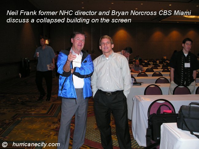
lastly.. there they are.. Patron Saint of Hurricanes: Neil Frank.
Miami's own Hurricane Angel: Bryan Norcross
at the Hurricane Conference this year in New Orleans......
Think what is going through their mind as you read this..
http://www.hurricanecity.com/images/neill.jpg
Lastly...the discussion.. the bottom line for us trackers and chasers who want to know what is really going on in the minds of the men at the National Hurricane Center. Most people don't read the discussion and they lose a lot in translation by just reading the Public Advisory. Here is where they play, they write..there is innuendo and previews of changes in their track. This is what we wait for..
For now.. the bottom line. I may have my thoughts and there are a few out there worth reading but.. this is the Bottom Line. The Buck Stops Here:
Hurricane Katrina Discussion Number 23
Statement as of 11:00 am EDT on August 28, 2005The Air Force hurricane hunters just measured a 166 kt flight level
wind in the northeast eyewall...which requires an additional upward
adjustment of the current intensity to 150 kt. A drop in the eye
gave a central pressure of 907 mb. Katrina is comparable in
intensity to hurricane Camille of 1969...only larger. GPS
dropsonde data from the NOAA G-IV mission earlier today showed
Katrina's intense cyclonic circulation extending through the 200 mb
level...with the flow spiraling anticylonically outward in a
well-developed upper-level outflow pattern beyond a couple hundred
N mi from the center. Fluctuations in strength...due to internal
structural changes...are likely prior to landfall. Hurricanes
rarely sustain such extreme winds for much time. However we see
no obvious large-scale effects to cause a substantial weakening the
system...and it is expected that the hurricane will be of category
4 or 5 intensity when it reaches the coast.
There is no change to the track forecast. Katrina should gradually
turn toward the north...into a weakness in the subtropical ridge
associated with a large mid-latitude cyclone over the northern
United States and southern Canada. The official forecast track is
about in the middle of the dynamical guidance models...which are
rather tightly clustered. Recalling that the average NHC 24-hour
track forecast error is about 80 N mi...the actual landfall point
could still be anywhere from southeastern Louisiana to the
Mississippi coast. Also...we must continue to stress that the
hurricane is not just a point on the map...because destructive
winds...torrential rains...storm surge...and dangerous waves extend
well away from the eye. It is impossible to specify which County
or Parish will experience the worst weather.
This advisory shows an additional expansion of the wind field over
the eastern semicircle based on aircraft and surface observations.
Hurricane force winds are forecast to spread at least 150 N mi
inland along the path of Katrina. Consult inland warnings issued
by National Weather Service forecast offices.
Forecaster Pasch
forecast positions and Max winds
initial 28/1500z 26.0n 88.1w 150 kt
12hr VT 29/0000z 27.2n 88.9w 145 kt
24hr VT 29/1200z 29.1n 89.6w 140 kt
36hr VT 30/0000z 31.4n 89.5w 85 kt...inland
48hr VT 30/1200z 34.5n 88.5w 45 kt...inland
72hr VT 31/1200z 40.0n 84.0w 30 kt...inland
96hr VT 01/1200z 45.0n 77.0w 25 kt...extratropical
120hr VT 02/1200z 52.0n 69.0w 25 kt...extratropical
$$
posted by BobbiStorm @ 9:36 AM
![]()


0 Comments:
Post a Comment
<< Home