Truly the Night of the Twisters… Multiple PDS Tornadoes Touching Down All Night in Oklahoma
add pics in the morning….

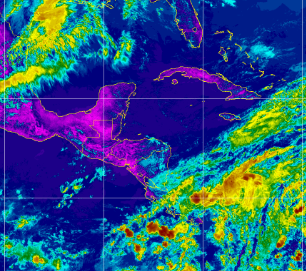
By the time you read this........the sun will have come up and we will see the horrific damage in Sulphur, Oklahoma and many other towns from Oklahoma to Kansas to ...well earlier tonight there was a warning for a town in Michigan while chasers were chasing in Oklahoma. Dawn will make the damage from the day before look doubled, tripled as this wild line snakes its way through an area known for bad tornadoes but this truly was the Night of the Tornadoes... Twisters. And, when you watch the new Twister remember that's not real and this is real........ and while many are sleeping when you wake up in Dallas at sunrise there will be thunderstorms .....
I wrote a friend earlier tonight on the importance of getting the word out on the dangers of the 2024 Hurricane Season. What if it's as bad as many have forecast and there are two hurricanes making landfall at the same time in different areas? Part of that letter is is below:
"ya know.... it's rare Ryan Hall Y'all is at a loss for words. One town actually got hit multiple times by and now has a flash flood alert. Amazingly the 2nd set of tornadoes missed the part of the town that's still whole. And, I know as someone who can talk as much as you and I can...that's freaky, humbling... sometimes it's hard to find the words even while you are live online"
This is truly the Night of the Twisters as there are weather warnings from Tx/Ok border to Michigan (?) and all the chasers are out there in different places getting footage of the damage which is epic from a historic perspective. Ryan Hall has been on air live 11 hours and has raised over $130,000 by way of his squad ...to be used to help whoever they can.
The Hurricane Season is 34 days away.
I cannot over emphasize the dangers inherent in the 2024 Hurricane Season IF the forecasts verify, and so far there hasn't been a forecast that predicts a normal or slow season so I'd take these warnings seriously. Many have said this will be like 2017, though who really knows.... one analog year from CSU is 1926 and we really do not want such a year again such as that one. Three different Major Hurricanes... hit South Florida, Cuba and the Bahamas, each legendary in their own right.
I'll be offline Monday and Tuesday for the end of the Passover holiday and then I'll be back ready to talk about the 2024 Hurricane Season full time as we are getting closer to Prime Time.
As always mitgating factors can show up in real time that make storm tracks take storms out to sea and inhibit hurricane development despite really hot water in the MDR as we have seen in the recent past. But, never rely on a miracle. Feel free to pray for a miracle but never rely on one.
You know the old story about the guy and the boat and the rope then the helicopter who complained why he wasn't warned by God ...variations abound.
Get a plan. Be ready to put that plan into action. Remember the year Florida got hit by 3 or 4 hurricanes criss crossing the state with tracks and all the cartoons, it really wasn't funny............
Prioritize your personal plan.... do you have children or elderly people living with you or dogs or fish?
You can begin putting together supplies while supplies are on sale. You don't have to wait until you are in the 3 Day Cone when nothing is left at the market.
The NHC and the NWS both provide you with early warning. Way earlier than Ardmore, Sulphur and other cities tonight got though they knew in general there'd be tornadoes.
Hurricane Ian was predicted to form when it was a weak wave out in the Atlantic and the focus area was obvious and yet people complained it hit Fort Myers Beach not Tampa and it never occurred to people watching Naples it might flood? Seriously? Ask the ghosts of those who died in the 1926 Hurricane what it was like to have no warning until hours before and most thought Miami Beach was flooding due to heavy rain and knew nothing about storm surge.
Hurricanes are one of the only disasters you can prepare for in advance, and if nothing hits you ...then you have snacks for the next month or so and you can use the money you saved to evacuate to go to Daytona or Orlando. When moneity is tight the Dollar Store has great non-perishable foods you can buy for $1.25 all you have to do is hide them from the kids, your spouse or yourself so they will be there when you find yourself in the Cone and by the time you get to the store all the good stuff will be gone and all you'll find is canned oysters.
I'll be updating in the morning with images after the sun rises.
I'm gonna go watch Thor's video and go to sleep.
Prayers for all those whose lives were shattered tonight and who may have lost loved ones not just the place they work or their home or their school
I saw Merle sing this song once upon a time live…
posted by BobbiStorm @ 11:00 PM
0 comments
![]()
.gif)


.gif)


.gif)


.gif)
.gif)
.gif)


